

At a glance
Distance
Elevation gain
Difficulty
Route type
Time
Permit required
Fees
Dogs
Best season
Official park info: Salmon-Challis National Forest
A brutally steep 3.5-mile climb to the 12,662-foot summit of Idaho's highest peak, with exposed scrambling on the knife-edge Chicken Out Ridge.
Borah Peak is the highest mountain in Idaho, and the standard route is a short but punishing climb. The Forest Service lists the traditional Southwest Ridge route at 3.5 miles one way, starting at about 7,400 ft and gaining 5,262 ft to the 12,662-foot summit. The climb isn't complex, but the steepness makes it very tiring.
The crux is Chicken Out Ridge, a knife-edge stretch where you'll use your hands as well as your feet, with the more dangerous drop on the north side. The reward is a view across the Lemhi, Salmon River, White Cloud, Boulder, Sawtooth and Pioneer ranges, plus Leatherman Peak, Idaho's second-highest mountain.
Plan your visit
Getting there
The trailhead is off U.S. Highway 93, 21 miles north of Mackay or 33 miles south of Challis. Signs for the Mt. Borah Trailhead turnoff are between mileposts 129 and 130. Follow the Borah Peak Access Road about 3 miles to the trailhead.
Parking
About 2.5 miles in, a large flat area is set aside for trailers and motor homes, because the final stretch is for regular vehicles only. Day parking and a turnaround are at the end of the road. The trailhead camping area has five campsites and an accessible vault toilet, but no drinking water and no garbage pickup. Pack out your trash.
Permits & fees
No permits are needed to climb, camp or build a fire, according to the Forest Service. Check the fire danger first, because fires aren't allowed when conditions are extreme. The trailhead campsites cost $5 per night (cash or check) during their May 20–September 30 season.
When to go
The Forest Service says conditions are best from early July to mid-August, when the snow level is lowest. A steep couloir past Chicken Out Ridge usually holds packed snow. Storms in late August often leave a couple of inches of snow at the base of the peak. Afternoon thunderstorms are common in summer and can build in a few hours, which is dangerous on an exposed ridge. Start early.
Good to know
- This is a long day. The Forest Service estimates 6–7 hours up and 10–12 hours round trip for an average hiker, not counting time on top. Some climbers camp on the ridge and make it two days.
- There's no water at the trailhead. Don't drink from streams untreated, since some carry Giardia. Bring water from a municipal supply or boil it.
- Bury or cover human waste.
- The scarp along the base of the range comes from the magnitude 7.3 Borah Peak earthquake of October 1983.
- A topo map is available at the Lost River Ranger District office in Mackay (208-588-3400).
Trailhead map
Trailhead at 44.1390, -113.7820. Confirm current trail conditions before you go.
Where to stay near Borah Peak (Dorrory Lake Route)
Find hotels and rentals near Borah Peak (Dorrory Lake Route)
We may earn a commission if you book a stay through these links, at no extra cost to you. Prices and availability come from booking partners and can change. We never rank trails by commission.
Route, step by step
1. Trailhead (about 7,400 ft). The trail leaves the turnaround and climbs a sagebrush and grass slope to the ridge.
2. West ridge. The real climbing starts here, straight up a brutally steep ridge to timberline.
Show full route
3. Above timberline. The ridge eases for a short distance, then steepens again.
4. Chicken Out Ridge. A knife-edge scramble over and around rocks, using hands and feet. The north side is the more dangerous drop.
5. Snow couloir. Cross a steep gully that's usually covered in packed snow. Some climbers use a trail through unstable shale on the north side instead.
6. Summit (12,662 ft, 3.5 mi). The route curves north up the final slope to a USGS survey marker and summit register. Descend the same way.
Tips
- Turn around if storms build. Chicken Out Ridge is a bad place to be in lightning.
- Plan your descent time. The trip down the steep ridge takes hours too.
Nearby trails we recommend
- Sawtooth Lake, in the Sawtooth Wilderness
- Alice Lake Trail, in the Sawtooth National Recreation Area
- Table Rock Trail, a short Boise hike
Tips
- Turn around if storms build. Chicken Out Ridge is a bad place to be in lightning. Plan your descent time. The trip down the steep ridge takes hours too.
What to bring & gear
- Sturdy hiking shoes or boots
- 2–3 liters of water per person
- Sun protection: hat, sunscreen, sunglasses
- Trail snacks or a packed lunch
- Trekking poles for the steep sections
- Headlamp and extra batteries
- Warm insulating layers for the summit
- Microspikes for early-season snow
Picks sized for a 7-mile, 8–12 hour hike.
Our gear picks
Our picks for this hike. Compare current prices at Amazon.

Hiking Boots
Our pickLightweight waterproof support for technical trails.
Salomon X Ultra 4 Mid GTX

Daypack
Our pickVentilated back panel and suspension for long days.
Osprey Stratos 24

Water Filter
Our pickFast-flow filter with a collapsible flask.
Katadyn BeFree 1L Filter Bottle

Trekking Poles
Our pickSaves your knees on steep descents.
Cascade Mountain Tech Carbon Fiber Trekking Poles
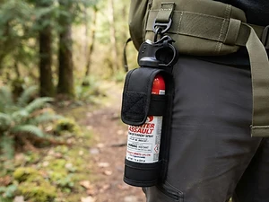
Bear Safety
Our pickCarried where it's reachable — a last-resort deterrent.
Bear Spray with Holster

Traction
Our pickGrip for icy or early-season snowy trail sections.
Kahtoola MICROspikes
As an Amazon Associate, Love Hiking Trails earns from qualifying purchases.
Photos

Featured in: The Best Hikes in Idaho
Places to eat (nearest is 18 mi away)
Few options nearby. Pack food and water.
Ratings & Comments
—
No ratings yet
Sign in to rate this trail and leave a comment.
No comments yet. Share what the trail was like for you.
Nearby
Nearby bike trails
Trails nearby
 ModerateHike
Tree Molds Trail
Craters of the Moon National Monument, Idaho
Walk a moonlike lava landscape to molds of ancient trees entombed by eruptions.
Distance
4 mi
Difficulty
Moderate
Type
Out and back
 StrenuousHike
Alice Lake Trail
Sawtooth National Recreation Area, Idaho
A scenic Sawtooth Wilderness hike from Pettit Lake to Alice Lake, a granite-ringed alpine lake beneath El Capitan.
Distance
12 mi
Difficulty
Strenuous
Type
Out & Back
 ChallengingHike
Sawtooth Lake (Iron Creek Trail)
Sawtooth Wilderness, Idaho
A popular climb from Iron Creek Trailhead past Alpine Lake to Sawtooth Lake, the largest alpine lake in the Sawtooths.
Distance
10 mi
Difficulty
Challenging
Type
Out and back
More trails to explore
More trails in Idaho
More hikes nearby
Frequently asked questions
How tall is Borah Peak?
The Forest Service lists the summit at 12,662 ft. It's the highest point in Idaho.
How long is the Borah Peak hike?
3.5 miles one way (7 round trip) with 5,262 ft of gain on the Southwest Ridge route.
How long does it take to climb Borah Peak?
Plan on 6–7 hours up and 10–12 hours round trip, per the Forest Service.
What is Chicken Out Ridge?
A knife-like section of the ridge near the top where you scramble with your hands and feet, with a dangerous drop on the north side.
Do I need a permit to climb Borah Peak?
No. The Forest Service doesn't require permits for climbing, camping or fires at present.
When is the best time to climb Borah Peak?
Early July through mid-August, when there's the least snow.