


Hike
Cantwell Cliffs Trail
Hocking Hills State Park, Ohio
2 mi450 ftChallenging
Hocking Hills' quietest gorge — rim trails, the Fat Woman's Squeeze, and a towering rock shelter.
View hike guide
Photo: aparlette, CC BY 2.0, via Wikimedia Commons
An interactive atlas of America's best hikes, mountain-bike routes and off-road trails — explore them on the map, then let the trail finder match a route to your ambition.
531
Mapped Routes
50
States
14,505′
Highest Peak
Pick your sport
300 hikes, 160 bike trails and 71 off-road areas across 50 states — on foot, on a bike, or behind the wheel. Pick a sport and start exploring.
Tuesday, November 17, 2026
One hike, one bike trail and one off-road route, picked fresh at midnight Central and the same for everyone all day.
Hocking Hills State Park, Ohio
Hocking Hills' quietest gorge — rim trails, the Fat Woman's Squeeze, and a towering rock shelter.
View hike guideGreenbrier River Trail State Park, West Virginia
West Virginia's longest rail trail: 78 miles and 35 bridges along the Greenbrier River.
View bike trail guideCanyonlands National Park (Island in the Sky), Utah
A 100-mile high-clearance four-wheel-drive loop in Canyonlands, open to street-legal 4x4s and motorbikes — not ATVs or UTVs — with a required day-use permit.
View off-road guideThe Continental Scale
Every hike, bike trail and off-road route in one map. Colors show the activity: green for hiking, orange for biking, brown for off-road. Use the region buttons to jump coast to coast.
Showing 300 hikes
The Full Atlas
300 hikes, 160 bike trails and 71 off-road areas across 50 states.
 EasyHike
Cheaha State Park, Alabama
An accessible boardwalk to a rocky overlook near Cheaha's summit.
Distance
0.6 mi
Difficulty
Easy
Type
Out & Back
 StrenuousHike
Chugach National Forest, Alaska
A climb past mining ruins to Crow Pass and Raven Glacier.
Distance
4 mi
Difficulty
Strenuous
Type
Out & Back
 StrenuousHike
Grand Canyon National Park, Arizona
The Grand Canyon's most popular trail, a long switchbacking descent below the South Rim where every mile down is a mile you must climb back out.
Distance
12 mi
Difficulty
Strenuous
Type
Out and back
 ModerateHike
Petit Jean State Park, Arkansas
Arkansas' signature waterfall hike — a steep stairway into a sandstone gorge beneath Petit Jean's rim.
Distance
2.2 mi
Difficulty
Moderate
Type
Out and back (with a return loop option)
 ModerateHike
Yosemite National Park, California
Granite spires mirrored in two high Sierra lakes off Tuolumne Meadows.
Distance
7 mi
Difficulty
Moderate
Type
Out and back (Upper and Lower lakes)
 ModerateHike
Rocky Mountain National Park, Colorado
Three alpine lakes in under two miles, ending under Hallett Peak.
Distance
3.4 mi
Difficulty
Moderate
Type
Out and back
 StrenuousHike
Mount Riga State Park, Connecticut
A climb to Connecticut's highest summit, topped by a stone tower ruin with views into three states.
Distance
6.4 mi
Difficulty
Strenuous
Type
Out & Back
 EasyHike
Trap Pond State Park, Delaware
A loop through the northernmost natural stand of bald cypress trees in the U.S.
Difficulty
Easy
Type
Loop
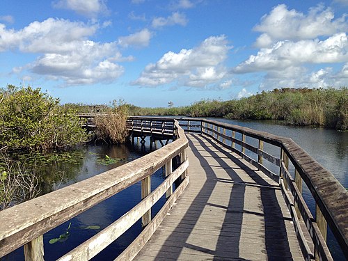 EasyHike
Everglades National Park, Florida
A flat, wheelchair-accessible 0.8-mile paved path and boardwalk at Royal Palm, and one of the best places in the Everglades to see alligators, turtles and wading birds up close.
Distance
0.8 mi
Difficulty
Easy
Type
Paved path leading to a looping boardwalk
Regional guides that rank the best hikes around each city and across each state, with drive times, distances and fees.
The Visual Sifter
Set your difficulty, your vibe, and how far or high you want to go. Matches update live.
Trail Finder
Filter by difficulty, vibe, distance, and elevation gain.
Tees and hats from Love Hiking Trails
Printed on demand and shipped by our print partner.
We use cookies for analytics, advertising (including third-party ad cookies) and affiliate tracking. You can accept all, reject non-essential cookies, or choose. See our Privacy Policy.


