

Hike
Cantwell Cliffs Trail
Hocking Hills State Park, Ohio
2 mi450 ftChallenging
Hocking Hills' quietest gorge — rim trails, the Fat Woman's Squeeze, and a towering rock shelter.
View hike guide
Every hiking trail in the atlas, across 50 states — from canyon narrows to glaciated volcanoes. Open any trail for its full guide: quick facts, gear list, nearby trails, and FAQ.
Hocking Hills State Park, Ohio
Hocking Hills' quietest gorge — rim trails, the Fat Woman's Squeeze, and a towering rock shelter.
View hike guideCity guides:Hikes near Huntsville
 StrenuousHike
Walls of Jericho, Alabama
A descent into a limestone amphitheater on the Paint Rock River headwaters, called the Grand Canyon of the South.
Distance
6.6 mi
Difficulty
Strenuous
Type
Out & Back
 ModerateHike
Cheaha State Park, Alabama
A short walk to a rocky overlook near the top of Alabama's highest mountain.
Distance
0.6 mi
Difficulty
Moderate
Type
Out & Back
 EasyHike
Cheaha State Park, Alabama
An accessible boardwalk to a rocky overlook near Cheaha's summit.
Distance
0.6 mi
Difficulty
Easy
Type
Out & Back
 ChallengingHike
Sipsey Wilderness (Bankhead National Forest), Alabama
A trail along the Sipsey Fork through Alabama's largest wilderness of canyons and waterfalls.
Difficulty
Challenging
Type
Out & Back
 EasyHike
Little River Canyon National Preserve, Alabama
A short boardwalk to Little River Falls at the head of one of the deepest canyons in the Southeast.
Difficulty
Easy
Type
Out & Back
 ExpertHike
Kenai Fjords National Park, Alaska
A steep climb beside Exit Glacier to an overlook of the vast Harding Icefield.
Distance
7.8 mi
Difficulty
Expert
Type
Out & Back
 StrenuousHike
Chugach State Park, Alaska
Alaska's most climbed mountain, a short steep hike above Anchorage.
Distance
3 mi
Difficulty
Strenuous
Type
Out & Back
 StrenuousHike
Denali National Park, Alaska
A steep climb from the Denali entrance area to an overlook above the Nenana River valley.
Distance
5.4 mi
Difficulty
Strenuous
Type
Out & Back
 EasyHike
Denali National Park, Alaska
An easy loop along the Savage River at the end of the public road in Denali.
Distance
2 mi
Difficulty
Easy
Type
Loop
 StrenuousHike
Chugach National Forest, Alaska
A climb past mining ruins to Crow Pass and Raven Glacier.
Distance
4 mi
Difficulty
Strenuous
Type
Out & Back
 StrenuousHike
Grand Canyon National Park, Arizona
The Grand Canyon's most popular trail, a long switchbacking descent below the South Rim where every mile down is a mile you must climb back out.
Distance
12 mi
Difficulty
Strenuous
Type
Out and back
 ModerateHike
Coconino National Forest, Arizona
Sedona's largest natural sandstone arch — a short, iconic red-rock walk.
Distance
4.2 mi
Difficulty
Moderate
Type
Out and back
 ChallengingHike
Paria Canyon–Vermilion Cliffs Wilderness, Arizona
Swirled Navajo sandstone in BLM's Coyote Buttes North, reached by a cross-country route. Only 64 people a day get in, all through a lottery.
Distance
6.4 mi
Difficulty
Challenging
Type
Out and back (cross-country, no marked trail)
 StrenuousHike
Grand Canyon National Park, Arizona
A steep, open ridgeline trail with the widest views of any South Rim route, plus no water and almost no shade.
Distance
6 mi
Difficulty
Strenuous
Type
Out and back
 StrenuousHike
Havasupai Indian Reservation, Arizona
An overnight-only trek into Havasu Canyon on Havasupai tribal land, to the turquoise waterfalls below the village of Supai. You'll need a paid reservation from the Havasupai Tribe.
Distance
20 mi
Difficulty
Strenuous
Type
Out and back (overnight)
 ChallengingHike
Coconino National Forest, Arizona
Sedona's most photographed spires, reached by a short, steep scramble that the Forest Service calls "more of a rock climb than a hike."
Distance
1.1 mi
Difficulty
Challenging
Type
Out and back
 ModerateHike
Ozark National Forest, Arkansas
Arkansas' most photographed bluff — a beak-shaped sandstone crag hanging over the Buffalo River wilderness.
Distance
3 mi
Difficulty
Moderate
Type
Out and back
 StrenuousHike
Buffalo National River, Arkansas
A steep 2.5-mile descent through the Ponca Wilderness to a waterfall that NPS says drops nearly 210 feet, the highest between the Rockies and the Appalachians. Then you climb all the way back out.
Distance
5 mi
Difficulty
Strenuous
Type
Out and back
 ModerateHike
Buffalo National River, Arkansas
A short box-canyon walk to a collapsed bluff shelter and Eden Falls, ending inside a cave.
Distance
2 mi
Difficulty
Moderate
Type
Out and back
 ModerateHike
Petit Jean State Park, Arkansas
Arkansas' signature waterfall hike — a steep stairway into a sandstone gorge beneath Petit Jean's rim.
Distance
2.2 mi
Difficulty
Moderate
Type
Out and back (with a return loop option)
 ModerateHike
Devil's Den State Park, Arkansas
A bluff-top rim walk over Lee Creek's box valley in the Ozarks' best-preserved CCC park.
Distance
3.8 mi
Difficulty
Moderate
Type
Loop
 ChallengingHike
Pinnacle Mountain State Park, Arkansas
A boulder-hop climb to the top of Little Rock's favorite cone-shaped mountain.
Distance
3 mi
Difficulty
Challenging
Type
Loop (West Summit up, East Summit down)
 ExpertHike
Yosemite National Park, California
Yosemite's icon — a 16-mile round trip ending in a cable climb up a 45° granite dome.
Distance
16 mi
Difficulty
Expert
Type
Out and back
 ExpertHike
Inyo National Forest, California
The Mount Whitney Trail climbs more than 6,000 ft in 11 miles from Whitney Portal. It's a non-technical route when snow-free, but its length and altitude make it a serious undertaking, and it needs a permit all year.
Distance
22 mi
Difficulty
Expert
Type
Out and back
 ChallengingHike
King Range National Conservation Area, California
A wild, roadless stretch of California coast — black sand, sea stacks, and elephant seals.
Distance
24.6 mi
Difficulty
Challenging
Type
Point to point (shuttle between trailheads)
 ModerateHike
Yosemite National Park, California
Granite spires mirrored in two high Sierra lakes off Tuolumne Meadows.
Distance
7 mi
Difficulty
Moderate
Type
Out and back (Upper and Lower lakes)
 StrenuousHike
Lassen Volcanic National Park, California
A steady, exposed climb from 8,500 feet up switchbacks on one of the world's largest plug dome volcanoes, with nonstop views from the summit area.
Distance
5 mi
Difficulty
Strenuous
Type
Out and back
 ExpertHike
Rocky Mountain National Park, Colorado
At 14,259 ft, Longs Peak is the highest summit in Rocky Mountain National Park. NPS is blunt about the Keyhole Route: "not a hike." It's a 15-mile, 10–15 hour climb across ledges and steep rock where an unroped fall would likely be fatal.
Distance
15 mi
Difficulty
Expert
Type
Out and back
 ChallengingHike
White River National Forest, Colorado
A turquoise hanging lake and waterfall tucked into Glenwood Canyon.
Distance
3.2 mi
Difficulty
Challenging
Type
Out and back
 StrenuousHike
San Juan National Forest, Colorado
A steep, wildly popular climb on Ice Lake Trail #505 near Silverton, rising from 9,840 to 12,260 feet into a wildflower-filled basin ringed by Grant, Fuller and Beatie peaks.
Distance
7 mi
Difficulty
Strenuous
Type
Out and back
 ExpertHike
White River National Forest, Colorado
A 27-mile circuit over four 12,500-foot passes beneath the Maroon Bells — Colorado's most famous backpack.
Distance
26.6 mi
Difficulty
Expert
Type
Loop
 StrenuousHike
Rocky Mountain National Park, Colorado
A 9.8-mile round trip from the Glacier Gorge Trailhead past Alberta Falls and The Loch, then up beside Timberline Falls and past Lake of Glass to Sky Pond.
Distance
9 mi
Difficulty
Strenuous
Type
Out and back
 ModerateHike
Rocky Mountain National Park, Colorado
Three alpine lakes in under two miles, ending under Hallett Peak.
Distance
3.4 mi
Difficulty
Moderate
Type
Out and back
City guides:Hikes near Hartford
 StrenuousHike
Mount Riga State Park, Connecticut
A climb to Connecticut's highest summit, topped by a stone tower ruin with views into three states.
Distance
6.4 mi
Difficulty
Strenuous
Type
Out & Back
 ModerateHike
Sleeping Giant State Park, Connecticut
A gentle carriage road to a stone observation tower atop the Giant's 'left hip.'
Distance
3.2 mi
Difficulty
Moderate
Type
Out & Back
 ModerateHike
Talcott Mountain State Park, Connecticut
A short ridge walk to the 165-foot Heublein Tower with views over the Farmington River valley.
Distance
2.5 mi
Difficulty
Moderate
Type
Out & Back
 EasyHike
Kent Falls State Park, Connecticut
A short stair trail beside a series of cascades in western Connecticut.
Distance
0.5 mi
Difficulty
Easy
Type
Out & Back
 ChallengingHike
Hubbard Park, Connecticut
A hike up the Hanging Hills to Castle Craig, a stone tower overlooking Meriden.
Distance
2.8 mi
Difficulty
Challenging
Type
Out & Back
City guides:Hikes near PhiladelphiaHikes near Wilmington
 EasyHike
Cape Henlopen State Park, Delaware
A flat coastal trail linking Rehoboth Beach and Cape Henlopen past a WWII observation tower and salt pond.
Difficulty
Easy
Type
Out & Back
 EasyHike
Trap Pond State Park, Delaware
A loop through the northernmost natural stand of bald cypress trees in the U.S.
Difficulty
Easy
Type
Loop
 EasyHike
Cape Henlopen State Park, Delaware
A rail trail between Lewes and Rehoboth Beach through woods and wetlands.
Distance
6 mi
Difficulty
Easy
Type
Out & Back
 ModerateHike
White Clay Creek State Park, Delaware
A wooded loop through rolling Piedmont hills along White Clay Creek.
Difficulty
Moderate
Type
Loop
 EasyHike
Prime Hook National Wildlife Refuge, Delaware
A short boardwalk through wetlands at a wildlife refuge known for migratory birds.
Distance
0.5 mi
Difficulty
Easy
Type
Loop
 ChallengingHike
Big Cypress National Preserve, Florida
Wade the nation's first national scenic trail through cypress domes and swamp prairie.
Distance
8 mi
Difficulty
Challenging
Type
Out and back
 EasyHike
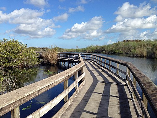
Everglades National Park, Florida
A flat, wheelchair-accessible 0.8-mile paved path and boardwalk at Royal Palm, and one of the best places in the Everglades to see alligators, turtles and wading birds up close.
Distance
0.8 mi
Difficulty
Easy
Type
Paved path leading to a looping boardwalk
 ChallengingHike
Myakka River State Park, Florida
A long prairie walk to a lake-edge lagoon where hundreds of alligators bask together.
Distance
12.6 mi
Difficulty
Challenging
Type
Out and back
 EasyHike
Apalachicola National Forest, Florida
A loop through karst terrain south of Tallahassee, linking sinkholes, a natural bridge and crystal-clear limestone pools in the Apalachicola National Forest.
Distance
3 mi
Difficulty
Easy
Type
Loop
 ModerateHike
Everglades National Park, Florida
A flat paved loop through the River of Grass to a 45-foot observation tower, famous for close-up alligator and wading bird sightings.
Distance
15 mi
Difficulty
Moderate
Type
Loop
City guides:Hikes near Atlanta
 ExpertHike
Cloudland Canyon State Park, Georgia
The Waterfalls Trail at Cloudland Canyon State Park is short, only 2 miles round trip, but the park rates it strenuous for a reason: 600 metal stair steps drop you into a canyon on the western edge of Lookout Mountain to two beautiful waterfalls, Cherokee Falls and Hemlock Falls. Going down is a joy.
Distance
2 mi
Difficulty
Expert
Type
Out-and-back
 ExpertHike
Amicalola Falls State Park, Georgia
For thousands of Appalachian Trail thru-hikers, the journey to Maine starts with a walk under a stone archway at Amicalola Falls State Park. From there, the blue-blazed Approach Trail climbs past a 729-foot waterfall, one of the tallest in the eastern U.S., and on to Springer Mountain, the A.T.'s southern terminus.
Distance
8.5 mi
Difficulty
Expert
Type
Point-to-point (Approach Trail) or out-and-back
 ChallengingHike
Chattahoochee National Forest, Georgia
Raven Cliff Falls is one of the most unusual waterfalls in the Southeast. Instead of pouring over a ledge, it shoots through a narrow split in a massive rock face, then drops into a pool below.
Distance
2.6 mi
Difficulty
Challenging
Type
Out-and-back
 StrenuousHike
Chattahoochee National Forest, Georgia
The most popular route to Blood Mountain, the highest point on Georgia's Appalachian Trail, with a historic stone shelter and sweeping summit views.
Distance
4.3 mi
Difficulty
Strenuous
Type
Out & Back
 ChallengingHike
Stone Mountain Park, Georgia
A short, steep climb up the bare granite dome of Stone Mountain to a summit with views of the Atlanta skyline.
Distance
2.2 mi
Difficulty
Challenging
Type
Out & Back
 ModerateHike
Kennesaw Mountain National Battlefield Park, Georgia
Atlanta's favorite Civil War summit climb, with skyline views from the top.
Distance
2.2 mi
Difficulty
Moderate
Type
Out and back
 ExpertHike
Nā Pali Coast State Wilderness Park, Hawaii
The legendary 11-mile Nā Pali Coast trail on Kauaʻi. For now only the first 2 miles (to Hanakāpīʻai) and the Hanakāpīʻai Falls spur are open, and access requires a Hāʻena State Park reservation.
Distance
22 mi
Difficulty
Expert
Type
Out and back
 ModerateHike
Diamond Head State Monument, Hawaii
A short crater-rim climb to Honolulu's most famous view — Waikiki and the endless Pacific.
Distance
1.6 mi
Difficulty
Moderate
Type
Out and back
 ChallengingHike
Haleakalā National Park, Hawaii
Walk into a Martian-colored volcano crater on the summit of Maui.
Distance
11 mi
Difficulty
Challenging
Type
Out and back
 ModerateHike
Haleakalā National Park, Hawaii
A 4-mile round-trip hike in Haleakalā's Kīpahulu District, past the overlook of nearly 200-foot Makahiku Falls and through a creaking bamboo forest to the base of 400-foot Waimoku Falls.
Distance
4 mi
Difficulty
Moderate
Type
Out and back
 ChallengingHike
Hawaiʻi Volcanoes National Park, Hawaii
A loop through rainforest and across the steaming floor of a lava lake that erupted in 1959.
Distance
3.3 mi
Difficulty
Challenging
Type
Loop
 ChallengingHike
Sawtooth Wilderness, Idaho
A popular climb from Iron Creek Trailhead past Alpine Lake to Sawtooth Lake, the largest alpine lake in the Sawtooths.
Distance
10 mi
Difficulty
Challenging
Type
Out and back
 StrenuousHike
Lost River Range, Idaho
A brutally steep 3.5-mile climb to the 12,662-foot summit of Idaho's highest peak, with exposed scrambling on the knife-edge Chicken Out Ridge.
Distance
7 mi
Difficulty
Strenuous
Type
Out and back
 ModerateHike
Craters of the Moon National Monument, Idaho
Walk a moonlike lava landscape to molds of ancient trees entombed by eruptions.
Distance
4 mi
Difficulty
Moderate
Type
Out and back
 ChallengingHike
Table Rock (Boise Foothills), Idaho
A popular foothills climb to the illuminated cross on Table Rock, with panoramic views over Boise and the Treasure Valley.
Distance
3.7 mi
Difficulty
Challenging
Type
Out & Back
 StrenuousHike
Sawtooth National Recreation Area, Idaho
A scenic Sawtooth Wilderness hike from Pettit Lake to Alice Lake, a granite-ringed alpine lake beneath El Capitan.
Distance
12 mi
Difficulty
Strenuous
Type
Out & Back
 EasyHike
Shawnee National Forest, Illinois
Wind-carved sandstone towers and bluff-top views over the Illinois Ozarks' wildest corner.
Distance
1.2 mi
Difficulty
Easy
Type
Loop
 ModerateHike
Starved Rock State Park, Illinois
Sandstone canyons, river-bluff overlooks and seasonal waterfalls along the Illinois River. Several eastern canyons are closed for a multi-year trail rebuild, so plan around the open western half.
Distance
2 mi
Difficulty
Moderate
Type
Loop / out and back on a trail network
 ModerateHike
Matthiessen State Park, Illinois
Starved Rock's quieter neighbor — a stream-walk canyon with stairways, cascade pools, and mossy walls.
Distance
3 mi
Difficulty
Moderate
Type
Loop
 EasyHike
Giant City State Park, Illinois
A short walk through the 'streets' of giant sandstone bluffs in the Shawnee Hills.
Distance
1 mi
Difficulty
Easy
Type
Loop
 ChallengingHike
Shawnee National Forest, Illinois
Sandstone cliffs, natural bridges, and cold swimming holes in the wildest corner of the Shawnee.
Distance
2.5 mi
Difficulty
Challenging
Type
Loop
 StrenuousHike
Turkey Run State Park, Indiana
Indiana's most famous rugged trail, climbing ladders and wading through sandstone ravines.
Distance
1.7 mi
Difficulty
Strenuous
Type
Loop
 StrenuousHike
Indiana Dunes State Park, Indiana
A sandy climb over the three tallest dunes in Indiana Dunes State Park.
Distance
1.5 mi
Difficulty
Strenuous
Type
Loop
 ChallengingHike
Indiana Dunes National Park, Indiana
A loop through wetlands, forest and dunes to a quiet Lake Michigan beach.
Distance
4.7 mi
Difficulty
Challenging
Type
Loop
 ModerateHike
Hoosier National Forest, Indiana
A short loop through a box canyon with sandstone cliffs and a seasonal waterfall.
Distance
1.2 mi
Difficulty
Moderate
Type
Loop
 ModerateHike
McCormick's Creek State Park, Indiana
A canyon walk to the waterfall in Indiana's first state park.
Difficulty
Moderate
Type
Out & Back
 ModerateHike
Effigy Mounds National Monument, Iowa
Bluff-top burial mounds shaped like bears and birds above the Mississippi River.
Distance
2 mi
Difficulty
Moderate
Type
Loop
 EasyHike
Maquoketa Caves State Park, Iowa
More than a dozen walk-in limestone caves strung along one trail — Iowa's most unusual park.
Distance
1.3 mi
Difficulty
Easy
Type
Loop
 ModerateHike
Ledges State Park, Iowa
Stone stairways down into the Des Moines River valley's sandstone ledges and Pea's Creek canyon.
Distance
2.5 mi
Difficulty
Moderate
Type
Loop
 ModerateHike
Backbone State Park, Iowa
Iowa's first state park — a ridge-of-bedrock walk over the 'Devil's Backbone' above the Maquoketa River.
Distance
5.5 mi
Difficulty
Moderate
Type
Loop
 ModerateHike
Palisades-Kepler State Park, Iowa
A river-bluff loop under 100-foot Cedar River cliffs in Iowa's little-known Driftless canyon park.
Distance
4 mi
Difficulty
Moderate
Type
Loop
 ChallengingHike
Konza Prairie Biological Station, Kansas
Loops across tallgrass prairie in the Flint Hills near Manhattan, Kansas.
Distance
2.6 mi
Difficulty
Challenging
Type
Loop
 ModerateHike
Tallgrass Prairie National Preserve, Kansas
A prairie trail climbing to an overlook in a preserve home to a bison herd.
Distance
6.5 mi
Difficulty
Moderate
Type
Out & Back
 EasyHike
Little Jerusalem Badlands State Park, Kansas
A trail to overlooks of the chalk formations of Kansas' newest state park.
Distance
2.5 mi
Difficulty
Easy
Type
Out & Back
 StrenuousHike
Elk City State Park, Kansas
A rocky trail through sandstone bluffs along Elk City Lake, often called one of Kansas' best.
Distance
15 mi
Difficulty
Strenuous
Type
Point to Point
 ChallengingHike
Kanopolis State Park, Kansas
Canyon trails among sandstone bluffs in Kansas' first state park.
Difficulty
Challenging
Type
Loop
City guides:Hikes near Lexington
 EasyHike
Red River Gorge, Daniel Boone National Forest, Kentucky
Walk across the top of a 75-foot natural arch in Kentucky's dense sandstone arch country.
Distance
1.4 mi
Difficulty
Easy
Type
Out and back
 ModerateHike
Red River Gorge, Daniel Boone National Forest, Kentucky
Stairs, ledges, and a ravine walk to the largest freestanding arch in the Red River Gorge.
Distance
1.5 mi
Difficulty
Moderate
Type
Out and back
 ModerateHike
Natural Bridge State Resort Park, Kentucky
The classic climb to a 65-foot sandstone arch you can walk across — Kentucky's original state park.
Distance
1.5 mi
Difficulty
Moderate
Type
Out and back (loop options on top)
 ModerateHike
Cumberland Falls State Resort Park, Kentucky
A cliff-and-creek descent to a 44-foot fall across the river from the famous Cumberland Falls.
Distance
2 mi
Difficulty
Moderate
Type
Out and back
 ModerateHike
Daniel Boone National Forest, Kentucky
A rhododendron-shaded stream walk to a two-tiered cascade in a narrow sandstone gorge.
Distance
2.5 mi
Difficulty
Moderate
Type
Out and back
 ChallengingHike
Red River Gorge, Daniel Boone National Forest, Kentucky
A ridgetop promenade over the Gorge's arch country, ending beneath the double tower of Courthouse Rock.
Distance
4.6 mi
Difficulty
Challenging
Type
Out and back (loop option via Double Arch)
 ChallengingHike
Kisatchie National Forest, Louisiana
A rugged trail through Kisatchie Hills Wilderness sandstone ridges.
Distance
7 mi
Difficulty
Challenging
Type
Point to Point
Kisatchie National Forest, Louisiana
Louisiana's longest hiking trail, famous for spring azalea blooms.
Difficulty
Challenging
Type
Point to Point
 EasyHike
Jean Lafitte National Historical Park and Preserve, Louisiana
Closed for repairs: A boardwalk through swamp and marsh at the Barataria Preserve near New.
Distance
1 mi
Difficulty
Easy
Type
Out & Back
 ChallengingHike
Chicot State Park, Louisiana
A long loop around Lake Chicot through hardwood forest and cypress.
Difficulty
Challenging
Type
Loop
 ChallengingHike
Tunica Hills Wildlife Management Area, Louisiana
Rugged loess bluffs and creek beds in Louisiana's hill country.
Difficulty
Challenging
Type
Out & Back
 StrenuousHike
Acadia National Park, Maine
Iron-rung ladders up a sheer cliff to the best ocean panorama on Mount Desert Island.
Distance
2.1 mi
Difficulty
Strenuous
Type
Out and back
 ExpertHike
Baxter State Park, Maine
Maine's highest peak and the northern end of the Appalachian Trail. Every route gains about 4,000 ft, and the Knife Edge is one of the most exposed ridge walks in the East.
Distance
11 mi
Difficulty
Expert
Type
Out and back or traverse (Knife Edge option)
 StrenuousHike
Acadia National Park, Maine
One of Acadia's famous rung-and-ladder trails, climbing iron rungs and granite stairs up a 450-foot cliff above Sand Beach, then returning by the gentler Bowl Trail.
Distance
1.5 mi
Difficulty
Strenuous
Type
Loop (up the Beehive, down the Bowl Trail)
 StrenuousHike
Acadia National Park, Maine
The longest route up Cadillac Mountain, the highest point on the U.S. Atlantic coast, climbing open granite ledges with ocean views.
Distance
7 mi
Difficulty
Strenuous
Type
Out & Back
 StrenuousHike
KI Jo-Mary Forest, Maine
A loop along the rim of the 'Grand Canyon of the East,' a slate gorge with a string of waterfalls along the West Branch of the Pleasant River.
Distance
8 mi
Difficulty
Strenuous
Type
Loop
City guides:Hikes near BaltimoreHikes near Washington
 StrenuousHike
Chesapeake and Ohio Canal National Historical Park, Maryland
A rock scramble along the Potomac's Mather Gorge near Great Falls.
Distance
4.7 mi
Difficulty
Strenuous
Type
Loop
 ModerateHike
Cunningham Falls State Park, Maryland
A trail to Maryland's largest cascading waterfall.
Distance
1 mi
Difficulty
Moderate
Type
Out & Back
 ChallengingHike
Sugarloaf Mountain, Maryland
A privately owned mountain open to the public, with views over the Piedmont.
Difficulty
Challenging
Type
Loop
 ChallengingHike
Appalachian Trail (South Mountain State Park), Maryland
An AT hike to a cliff overlook of Greenbrier Lake.
Distance
5.4 mi
Difficulty
Challenging
Type
Out & Back
 ModerateHike
Swallow Falls State Park, Maryland
A loop past Muddy Creek Falls, Maryland's tallest free-falling waterfall.
Distance
1.25 mi
Difficulty
Moderate
Type
Loop
City guides:Hikes near ProvidenceHikes near Boston
 StrenuousHike
Mount Greylock State Reservation, Massachusetts
A climb to Massachusetts' highest peak and its Veterans War Memorial Tower.
Difficulty
Strenuous
Type
Out & Back
 StrenuousHike
Blue Hills Reservation, Massachusetts
A rocky ridge trail near Boston to Great Blue Hill and Eliot Tower.
Distance
10 mi
Difficulty
Strenuous
Type
Out & Back
 EasyHike
Walden Pond State Reservation, Massachusetts
An easy 1.7-mile loop around the famous Concord pond that inspired Henry David Thoreau, with a side visit to the site of his cabin.
Distance
1.7 mi
Difficulty
Easy
Type
Loop
 ModerateHike
Bash Bish Falls State Park, Massachusetts
A short trail to the state's highest single-drop waterfall.
Distance
0.6 mi
Difficulty
Moderate
Type
Out & Back
 ChallengingHike
Cape Cod National Seashore, Massachusetts
A sandy hike on a peninsula in Wellfleet Harbor.
Distance
3.9 mi
Difficulty
Challenging
Type
Out & Back
 ChallengingHike
Pictured Rocks National Lakeshore, Michigan
Sandstone cliffs, waterfalls, and turquoise Lake Superior water on one great loop.
Distance
10.4 mi
Difficulty
Challenging
Type
Loop
 StrenuousHike
Porcupine Mountains Wilderness State Park, Michigan
A cliff-edge traverse above the Carp River valley — the Upper Peninsula's most spectacular day hike.
Distance
8.7 mi
Difficulty
Strenuous
Type
Point to point (out-and-back options)
 EasyHike
Sleeping Bear Dunes National Lakeshore, Michigan
A short beech-forest walk to a bluff over Lake Michigan, with Sleeping Bear Dune straight ahead.
Distance
1.5 mi
Difficulty
Easy
Type
Out and back
 EasyHike
Pictured Rocks National Lakeshore, Michigan
Stairway steps down to a five-tiered waterfall spilling toward Lake Michigan over Grand Sable Dunes.
Distance
1 mi
Difficulty
Easy
Type
Out and back
 EasyHike
Tahquamenon Falls State Park, Michigan
Boardwalk paths to the 'Root Beer Falls' — tea-colored water pouring over a wide amber curtain.
Distance
1 mi
Difficulty
Easy
Type
Loop (boardwalk network)
City guides:Hikes near Duluth
 ModerateHike
Superior National Forest, Minnesota
A short ridgetop loop with sweeping views of Lake Superior and maples on fire.
Distance
2.3 mi
Difficulty
Moderate
Type
Loop
 ModerateHike
Tettegouche State Park, Minnesota
A Baptism River gorge walk to Minnesota's tallest waterfall inside a rock amphitheater.
Distance
3 mi
Difficulty
Moderate
Type
Out and back
 ChallengingHike
Superior National Forest / BWCAW, Minnesota
The hike to Minnesota's highest point — a boreal-forest climb through the Boundary Waters.
Distance
3.5 mi
Difficulty
Challenging
Type
Out and back
 ChallengingHike
Cascade River State Park, Minnesota
A climb through maple ridges to a fire-tower summit overlooking Lake Superior's North Shore.
Distance
5.5 mi
Difficulty
Challenging
Type
Loop
 ModerateHike
Gooseberry Falls State Park, Minnesota
Beyond the crowded lower falls — a quiet gorge walk to the park's fifth and least-visited cascade.
Distance
3 mi
Difficulty
Moderate
Type
Loop
 ChallengingHike
Split Rock Lighthouse State Park, Minnesota
A Superior shoreline walk beneath the most photographed lighthouse on the Great Lakes.
Distance
3.2 mi
Difficulty
Challenging
Type
Out and back
 ChallengingHike
Clark Creek Natural Area, Mississippi
Waterfalls in loess bluffs near Woodville.
Distance
1.5 mi
Difficulty
Challenging
Type
Out & Back
 EasyHike
Natchez Trace Parkway, Mississippi
A boardwalk loop through tupelo-cypress swamp.
Distance
0.4 mi
Difficulty
Easy
Type
Loop
 ModerateHike
Tishomingo State Park, Mississippi
A trail among sandstone outcrops and a swinging bridge in the Appalachian foothills of Mississippi.
Difficulty
Moderate
Type
Loop
 ChallengingHike
De Soto National Forest, Mississippi
Mississippi's longest trail along a Wild and Scenic River.
Distance
40 mi
Difficulty
Challenging
Type
Point to Point
 EasyHike
Longleaf Trace, Mississippi
A paved rail trail through pine forest from Hattiesburg.
Difficulty
Easy
Type
Point to Point
City guides:Hikes near St. Louis
 ModerateHike
Taum Sauk Mountain State Park, Missouri
Missouri's highest point plus the state's tallest waterfall, deep in the ancient St. Francois Mountains.
Distance
3.5 mi
Difficulty
Moderate
Type
Loop
 ModerateHike
Hawn State Park, Missouri
Pine forests, sandstone shut-ins, and Pickle Creek — the prettiest state-park hike in Missouri.
Distance
5.8 mi
Difficulty
Moderate
Type
Loop
 ModerateHike
Johnson's Shut-Ins State Park, Missouri
A loop over Goggins Mountain to the Black River's famous rock channel, polished into chutes and potholes.
Distance
2.4 mi
Difficulty
Moderate
Type
Loop
 EasyHike
Elephant Rocks State Park, Missouri
A chain of giant granite boulders, stacked like circus elephants on the crest of a granite dome.
Distance
1 mi
Difficulty
Easy
Type
Loop (Braille Trail)
 ModerateHike
Grand Gulf State Park, Missouri
A walk along the rim of a mile-long collapsed cave — 'Missouri's Little Grand Canyon.'
Distance
2.2 mi
Difficulty
Moderate
Type
Out and back (rim trail)
 ModerateHike
Rock Bridge Memorial State Park, Missouri
A sinkhole-and-boardwalk loop to a natural rock bridge and the dark mouth of the Devil's Icebox cave.
Distance
2.5 mi
Difficulty
Moderate
Type
Loop
 ChallengingHike
Glacier National Park, Montana
A steady climb from Many Glacier past turquoise lakes to the viewpoint over Grinnell Glacier. A concessioner boat can cut 1.3 miles off each way.
Distance
10 mi
Difficulty
Challenging
Type
Out and back (boat shortcut available in season)
 ChallengingHike
Glacier National Park, Montana
Glacier's most famous ridge walk, cut into the Garden Wall along the Continental Divide from Logan Pass. Most hikers end at The Loop, 11.8 miles later.
Distance
11.6 mi
Difficulty
Challenging
Type
Point to point (or out and back from Logan Pass)
 ModerateHike
Glacier National Park, Montana
A steady, mostly gentle climb from Many Glacier past Ptarmigan Falls to a cirque lake beneath sheer walls, where ice often floats well into summer.
Distance
9.4 mi
Difficulty
Moderate
Type
Out and back
 ChallengingHike
Glacier National Park, Montana
From Logan Pass along the Continental Divide to a tarn beneath Bearhat Mountain.
Distance
5.4 mi
Difficulty
Challenging
Type
Out and back
 ModerateHike
Glacier National Park, Montana
A steady climb through old-growth forest from the Trail of the Cedars to a mountain lake ringed by cliffs and waterfalls. NPS calls it an excellent introduction to Glacier.
Distance
4.5 mi
Difficulty
Moderate
Type
Out and back
 ModerateHike
Nebraska National Forest, Nebraska
A badland maze of mushroom-shaped rock spires under some of the darkest skies in America.
Distance
3 mi
Difficulty
Moderate
Type
Loop
 ModerateHike
Scotts Bluff National Monument, Nebraska
Hike through the Oregon Trail's most dramatic landmark — three tunnels and ruts included.
Distance
3.2 mi
Difficulty
Moderate
Type
Out and back (summit road plus trail)
 EasyHike
Smith Falls State Park, Nebraska
A short boardwalk walk across the Niobrara River to Smith Falls, the tallest waterfall in Nebraska.
Distance
0.6 mi
Difficulty
Easy
Type
Out & Back
 ChallengingHike
Fort Robinson State Park, Nebraska
A Pine Ridge loop in Fort Robinson State Park climbing past the Red Cloud Buttes to the Lover's Leap Butte, with sweeping views over the historic fort.
Distance
4.9 mi
Difficulty
Challenging
Type
Loop
 ChallengingHike
Fort Robinson State Park, Nebraska
An open loop off the Smiley Canyon Scenic Drive west of Fort Robinson, with buttes, rolling prairie and a chance to spot the park's bison herd.
Distance
6.2 mi
Difficulty
Challenging
Type
Loop
 ChallengingHike
Red Rock Canyon National Conservation Area, Nevada
A scramble up a sandstone canyon to a natural water tank with a view of Las Vegas.
Distance
2.5 mi
Difficulty
Challenging
Type
Out & Back
 ModerateHike
Valley of Fire State Park, Nevada
A short walk to swirling striped sandstone in Nevada's oldest state park.
Distance
1.5 mi
Difficulty
Moderate
Type
Out & Back
 ExpertHike
Great Basin National Park, Nevada
A high climb to the summit of 13,063-foot Wheeler Peak.
Distance
8.6 mi
Difficulty
Expert
Type
Out & Back
 ChallengingHike
Spring Mountains National Recreation Area, Nevada
A switchback climb to a seasonal waterfall in the Spring Mountains near Las Vegas.
Distance
3.2 mi
Difficulty
Challenging
Type
Out & Back
 ChallengingHike
Spring Mountains National Recreation Area, Nevada
A loop through ancient bristlecone pines in Lee Canyon.
Difficulty
Challenging
Type
Loop
 StrenuousHike
White Mountain National Forest, New Hampshire
An exposed alpine ridge over three 4,000-foot peaks — a National Geographic dream trail.
Distance
8.9 mi
Difficulty
Strenuous
Type
Loop
 ModerateHike
Crawford Notch State Park, New Hampshire
A rocky, steady climb off Route 302 to Arethusa Falls, which NH State Parks calls the highest falls in New Hampshire at nearly 200 feet.
Distance
2.8 mi
Difficulty
Moderate
Type
Out and back (or a 4-mile loop past Frankenstein Cliff)
 ChallengingHike
White Mountain National Forest, New Hampshire
The White Mountains' classic day loop — two open granite domes with 360° southern-range views.
Distance
4.4 mi
Difficulty
Challenging
Type
Loop
 ExpertHike
White Mountain National Forest, New Hampshire
The classic, steep climb up the Northeast's highest peak through a glacial cirque, starting from Pinkham Notch.
Distance
8.4 mi
Difficulty
Expert
Type
Out & Back
 StrenuousHike
Monadnock State Park, New Hampshire
A steep, rocky climb up one of the most-hiked mountains in the world, with a bare summit and views across New England.
Distance
4 mi
Difficulty
Strenuous
Type
Out & Back
City guides:Hikes near New York City
 StrenuousHike
Delaware Water Gap National Recreation Area, New Jersey
A steep rocky climb to cliff views over the Delaware Water Gap.
Distance
3.5 mi
Difficulty
Strenuous
Type
Loop
 StrenuousHike
Appalachian Trail (Wawayanda State Park), New Jersey
An AT climb up stone steps to Pinwheel Vista.
Distance
2.6 mi
Difficulty
Strenuous
Type
Out & Back
 ModerateHike
Delaware Water Gap National Recreation Area, New Jersey
New Jersey's tallest waterfall, with stairs to the top.
Difficulty
Moderate
Type
Out & Back
 ChallengingHike
Worthington State Forest, New Jersey
An AT hike to a glacial pond on Kittatinny Ridge.
Distance
7.6 mi
Difficulty
Challenging
Type
Out & Back
 ChallengingHike
Pyramid Mountain Natural Historic Area, New Jersey
A rugged Highlands loop past Tripod Rock, Bear Rock and Whale Head Rock, giant glacial erratics left by the Wisconsin Glacier, with a view toward New.
Distance
4.1 mi
Difficulty
Challenging
Type
Loop
City guides:Hikes near Santa Fe
 ChallengingHike
Carson National Forest, New Mexico
New Mexico's high point — a glacial cirque climb above the Sangre de Cristo range.
Distance
8.2 mi
Difficulty
Challenging
Type
Out and back
 StrenuousHike
Sandia Mountains, Cibola National Forest, New Mexico
Albuquerque's great climb — 3,700 feet up the Sandias' west face to a 10,378-foot crest.
Distance
9 mi
Difficulty
Strenuous
Type
Out and back (tram descent option)
 ModerateHike
Kasha-Katuwe Tent Rocks National Monument, New Mexico
Walk a slot canyon between cone-shaped rock tents, climbing to a rim view over the monument.
Distance
2.7 mi
Difficulty
Moderate
Type
Loop plus slot-canyon out and back
 ModerateHike
Bandelier National Monument, New Mexico
A canyon walk past Ancestral Puebloan cliff dwellings to a ceremonial cave reached by four long ladders.
Distance
2.5 mi
Difficulty
Moderate
Type
Loop (Main Loop) with Alcove House spur
 ModerateHike
Wheeler Peak Wilderness, Carson National Forest, New Mexico
A high glacial-lake stroll beneath Wheeler Peak — New Mexico's high point — in the Sangre de Cristos.
Distance
4.2 mi
Difficulty
Moderate
Type
Out and back
 ModerateHike
Ghost Ranch, Abiquiu, New Mexico
A climb to a boxed lookout over the red-and-gold cliffs Georgia O'Keeffe painted for decades.
Distance
3 mi
Difficulty
Moderate
Type
Out and back
City guides:Hikes near Albany
 ChallengingHike
Adirondack High Peaks, New York
The easiest of the Adirondack 46 High Peaks — a great first summit with open rock views.
Distance
4.8 mi
Difficulty
Challenging
Type
Out and back
 StrenuousHike
Adirondack High Peaks, New York
New York's highest summit via the Adirondacks' most scenic — and muddiest — route.
Distance
14.8 mi
Difficulty
Strenuous
Type
Out and back
 ModerateHike
Watkins Glen State Park, New York
Stone stairways, tunnels and bridges carry the Gorge Trail past 19 waterfalls in the Finger Lakes' best-known glen.
Distance
3 mi
Difficulty
Moderate
Type
Out & Back
 ModerateHike
Catskill Park, New York
A short walk from Laurel House Road to a viewing platform above New York's highest cascading waterfall, with a steeper stair-lined trail down to the pools at its base.
Distance
1.2 mi
Difficulty
Moderate
Type
Out and back
 ChallengingHike
Letchworth State Park, New York
A rim trail along the 'Grand Canyon of the East' passing the Upper, Middle and Lower Falls of the Genesee River.
Distance
7 mi
Difficulty
Challenging
Type
Point to Point
City guides:Hikes near AshevilleHikes near Johnson City
 ModerateHike
Pisgah National Forest, North Carolina
Grassy bald ridges along the Appalachian Trail — a rhododendron bloom and fall-color legend.
Distance
7 mi
Difficulty
Moderate
Type
Out and back along the balds
 ChallengingHike
Pisgah National Forest, North Carolina
Driving US-276 through Pisgah National Forest, it's hard to miss Looking Glass Rock: a massive granite dome whose wet rock faces shine like a mirror after rain. The trail to the top is a steady, switchbacking climb through changing forest to open rock with sweeping views north toward the Blue Ridge Parkway.
Distance
3.1 mi
Difficulty
Challenging
Type
Out-and-back
 ModerateHike
Great Smoky Mountains National Park, North Carolina
On the North Carolina side of the Smokies, just outside Bryson City, the Deep Creek area packs three waterfalls into one short loop: Juney Whank Falls, Tom Branch Falls, and Indian Creek Falls. It's an easy-to-moderate half-day outing with a lot of reward, and a great choice for families or anyone who wants a variety of waterfalls without a long climb.
Distance
2.4 mi
Difficulty
Moderate
Type
Loop (with a short out-and-back spur to Indian Creek Falls)
 ChallengingHike
Blue Ridge Parkway, North Carolina
Linville Falls is one of the most impressive waterfalls on the Blue Ridge Parkway. The Linville River pours over the Upper Falls, squeezes through a narrow canyon, and then plunges 45 feet over the Lower Falls into the head of Linville Gorge.
Distance
1.18 mi
Difficulty
Challenging
Type
Out-and-back
 EasyHike
Pisgah National Forest, North Carolina
Max Patch is the iconic grassy bald of the Southern Appalachians: a 4,629-foot summit with 360-degree views from Mount Mitchell to the east to the Great Smoky Mountains to the southwest. The Appalachian Trail crosses right over it.
Distance
1.5 mi
Difficulty
Easy
Type
Loop (A.T. + summit trail)
 ChallengingHike
Great Smoky Mountains National Park, North Carolina
Picture a high, open meadow ringed by spruce and fir, with blueberry bushes and blooming azaleas at your feet and blue ridgelines stacked to the horizon. That's Andrews Bald.
Distance
3.6 mi
Difficulty
Challenging
Type
Out-and-back (downhill first)
City guides:Hikes near Medora
 EasyHike
Theodore Roosevelt National Park, North Dakota
Descend into North Dakota's painted badlands — banded buttes, junipers, and bison country.
Distance
0.9 mi
Difficulty
Easy
Type
Loop
 EasyHike
Theodore Roosevelt National Park, North Dakota
A short rim walk through a wind-carved canyon to a view over the Little Missouri badlands.
Distance
0.8 mi
Difficulty
Easy
Type
Out and back
 ModerateHike
Theodore Roosevelt National Park, North Dakota
A North Unit nature loop through banded badlands, caprock tables, and prairie dog towns.
Distance
1.4 mi
Difficulty
Moderate
Type
Loop
 ChallengingHike
Theodore Roosevelt National Park, North Dakota
A long badlands loop past 55-million-year-old petrified stumps lying where ancient swamps stood.
Distance
9 mi
Difficulty
Challenging
Type
Loop
 StrenuousHike
Little Missouri National Grassland, North Dakota
A 144-mile singletrack epic through the Little Missouri badlands — the longest continuous trail in America's grasslands.
Distance
144 mi
Difficulty
Strenuous
Type
Point to point
 ChallengingHike
Theodore Roosevelt National Park, North Dakota
The North Unit's longest hike — a full-day badlands loop past big prairie dog towns and hidden canyons.
Distance
11 mi
Difficulty
Challenging
Type
Loop
 EasyHike
Hocking Hills State Park, Ohio
A one-way gorge walk past Upper Falls, Devil's Bathtub, the Old Man's Cave recess and Lower Falls, the most visited corner of Ohio's Hocking Hills.
Distance
1 mi
Difficulty
Easy
Type
One-way gorge loop (follow directional signs)
 ModerateHike
Cuyahoga Valley National Park, Ohio
A cliff-lined loop under mossy sandstone ledges, past Ice Box Cave and Ledges Overlook.
Distance
2.2 mi
Difficulty
Moderate
Type
Loop
 EasyHike
Cuyahoga Valley National Park, Ohio
A 65-foot curtain waterfall pouring off a sandstone ledge — Cuyahoga Valley's signature sight.
Distance
1.5 mi
Difficulty
Easy
Type
Loop (boardwalk and gorge)
 ModerateHike
Clifton Gorge State Nature Preserve, Ohio
The Little Miami River threading through a narrow dolomite gorge — one of Ohio's finest walks.
Distance
2.6 mi
Difficulty
Moderate
Type
Out and back (loop into John Bryan State Park)
 ChallengingHike
Hocking Hills State Park, Ohio
The deepest, sheerest gorge in Hocking Hills — a rim walk above a box canyon with 200-foot walls.
Distance
3.5 mi
Difficulty
Challenging
Type
Loop (rim trail is one-way)
 ChallengingHike
Hocking Hills State Park, Ohio
Hocking Hills' quietest gorge — rim trails, the Fat Woman's Squeeze, and a towering rock shelter.
Distance
2 mi
Difficulty
Challenging
Type
Loop
 ChallengingHike
Wichita Mountains Wildlife Refuge, Oklahoma
A granite climb with views across the Wichita Mountains.
Distance
2.2 mi
Difficulty
Challenging
Type
Out & Back
 StrenuousHike
Wichita Mountains Wildlife Refuge, Oklahoma
A boulder-strewn wilderness trail among granite.
Difficulty
Strenuous
Type
Out & Back
 ChallengingHike
Robbers Cave State Park, Oklahoma
A trail to a sandstone cave tied to outlaw legends.
Difficulty
Challenging
Type
Loop
 EasyHike
Chickasaw National Recreation Area, Oklahoma
A creekside walk to travertine falls at Chickasaw NRA.
Difficulty
Easy
Type
Out & Back
 ChallengingHike
Wichita Mountains Wildlife Refuge, Oklahoma
A climb up Mount Scott, one of Oklahoma's most famous summits.
Distance
2.8 mi
Difficulty
Challenging
Type
Out & Back
 ChallengingHike
Crater Lake National Park, Oregon
The only legal route to the shore of America's deepest, bluest lake.
Distance
2.2 mi
Difficulty
Challenging
Type
Out and back
 StrenuousHike
Mount Hood National Forest, Oregon
A 40-mile lap around Mount Hood with volcano views, wildflowers, and glacial river fords.
Distance
38.6 mi
Difficulty
Strenuous
Type
Loop
 StrenuousHike
Deschutes National Forest, Oregon
A relentless climb up Oregon's third-tallest volcano to a crater rim beside a turquoise lake.
Distance
11.2 mi
Difficulty
Strenuous
Type
Out and back
 StrenuousHike
Columbia River Gorge National Scenic Area, Oregon
A 4.8-mile waterfall loop that links Wahkeena Falls, Fairy Falls and the top of 620-foot Multnomah Falls, the most visited natural recreation site in the Pacific Northwest.
Distance
5 mi
Difficulty
Strenuous
Type
Loop
 StrenuousHike
Smith Rock State Park, Oregon
A steep loop over Smith Rock's famous ridge with views of Monkey Face and the Crooked River.
Distance
3.7 mi
Difficulty
Strenuous
Type
Loop
 StrenuousHike
Ricketts Glen State Park, Pennsylvania
Pennsylvania's famous waterfall hike drops through two old-growth glens past 21 named waterfalls, from 11-foot cascades to 94-foot Ganoga Falls.
Distance
7.2 mi
Difficulty
Strenuous
Type
Loop or out and back
 StrenuousHike
Appalachian Trail (Hamburg Reservoir), Pennsylvania
A popular AT loop to two great Pennsylvania overlooks.
Difficulty
Strenuous
Type
Loop
 ChallengingHike
Hawk Mountain Sanctuary, Pennsylvania
A rocky walk to a famous raptor-watching lookout.
Distance
1.9 mi
Difficulty
Challenging
Type
Out & Back
 StrenuousHike
Leonard Harrison State Park, Pennsylvania
A steep descent into the Pennsylvania Grand Canyon past waterfalls.
Difficulty
Strenuous
Type
Out & Back
 ModerateHike
Ohiopyle State Park, Pennsylvania
A loop on a peninsula in the Youghiogheny River.
Difficulty
Moderate
Type
Loop
 ModerateHike
Newport Cliff Walk, Rhode Island
A shoreline path past Gilded Age mansions.
Distance
3.5 mi
Difficulty
Moderate
Type
Point to Point
 ModerateHike
Block Island, Rhode Island
Stairs down to a beach beneath 150-foot clay bluffs.
Difficulty
Moderate
Type
Out & Back
 ModerateHike
Norman Bird Sanctuary, Rhode Island
A trail to a puddingstone ridge overlooking the ocean.
Distance
2 mi
Difficulty
Moderate
Type
Out & Back
Arcadia Management Area, Rhode Island
Stair-like ledges on the Wood River.
Distance
0.1 mi
Difficulty
Moderate
Type
Out & Back
 EasyHike
Napatree Point Conservation Area, Rhode Island
A sandy barrier spit walk to a ruined fort.
Distance
3 mi
Difficulty
Easy
Type
Out & Back
City guides:Hikes near Greenville
 ExpertHike
Table Rock State Park, South Carolina
A steep climb to the summit of Table Rock.
Distance
7.2 mi
Difficulty
Expert
Type
Out & Back
 EasyHike
Congaree National Park, South Carolina
A 2.6-mile, wheelchair-accessible boardwalk from the Harry Hampton Visitor Center into old-growth bottomland forest, among bald cypress and tupelo trees.
Distance
2.6 mi
Difficulty
Easy
Type
Not officially published (NPS lists a round-trip distance)
 StrenuousHike
Jones Gap State Park, South Carolina
A steep climb to a 100-foot waterfall.
Distance
4.4 mi
Difficulty
Strenuous
Type
Out & Back
 ChallengingHike
Duke Energy Bad Creek, South Carolina
A trail to an overlook of a towering waterfall in the Jocassee Gorges.
Distance
3.8 mi
Difficulty
Challenging
Type
Out & Back
 ModerateHike
Sumter National Forest, South Carolina
A forest trail to a cascade over layered rock.
Distance
3.2 mi
Difficulty
Moderate
Type
Out & Back
City guides:Hikes near Rapid City
 StrenuousHike
Badlands National Park, South Dakota
A short but adventurous Badlands hike through a canyon, up a log-and-cable ladder and along a ledge to "the Notch," with a view over the White River Valley. It's currently closed for ladder repairs.
Distance
1.5 mi
Difficulty
Strenuous
Type
Out and back
 ChallengingHike
Black Elk Wilderness, Black Hills National Forest, South Dakota
South Dakota's highest point, topped by a 1930s stone fire lookout with views over four states.
Distance
7.4 mi
Difficulty
Challenging
Type
Out and back (loop option)
 StrenuousHike
Custer State Park, South Dakota
A rugged Black Hills loop from Sylvan Lake down a granite gulch with handrails, boulders and a creek.
Distance
4 mi
Difficulty
Strenuous
Type
Loop
 StrenuousHike
Custer State Park, South Dakota
A Black Hills climb to a rocky summit with a view of Black Elk Peak and the Needles.
Distance
3.5 mi
Difficulty
Strenuous
Type
Out & Back
 ChallengingHike
Badlands National Park, South Dakota
The longest maintained trail in Badlands National Park, crossing mixed-grass prairie between eroded buttes.
Distance
10 mi
Difficulty
Challenging
Type
Out & Back
City guides:Hikes near KnoxvilleHikes near GatlinburgHikes near CookevilleHikes near Nashville
 ChallengingHike
Great Smoky Mountains National Park, Tennessee
The Smokies' highest lodge, reached by the dramatic Alum Cave trail past Arch Rock.
Distance
11 mi
Difficulty
Challenging
Type
Out and back
 ChallengingHike
Great Smoky Mountains National Park, Tennessee
A rocky knuckle of the Appalachian Trail with a dizzying view over the Smokies.
Distance
8 mi
Difficulty
Challenging
Type
Out and back
 ExpertHike
Great Smoky Mountains National Park, Tennessee
In late June, Gregory Bald puts on one of the great wildflower shows in the eastern United States. Thousands of flame azaleas bloom in orange, red, yellow, pink, and white across a high grassy meadow at 4,900 feet, with views straight down into Cades Cove.
Distance
11.4 mi
Difficulty
Expert
Type
Out-and-back (loop options)
 ModerateHike
Radnor Lake State Park, Tennessee
Ten minutes from Green Hills, Radnor Lake State Park feels like another world: an 85-acre lake ringed by forested ridges, herons stalking the shallows, turtles sunning on logs, and owls calling at dusk. It's protected as a Class II Natural Area, so the trails are for hiking and wildlife watching only.
Distance
3 mi
Difficulty
Moderate
Type
Loops and connectors
 ChallengingHike
Short Springs State Natural Area, Tennessee
Machine Falls is one of Middle Tennessee's prettiest surprises: a wide, stair-stepped cascade that drops more than 60 feet and is nearly as wide as it is tall, hidden in a ravine just outside Tullahoma. In spring, Short Springs is also one of the best wildflower hikes in the state.
Distance
2 mi
Difficulty
Challenging
Type
Out-and-back or loop
 ExpertHike
Great Smoky Mountains National Park, Tennessee
Perched on a rocky knob at the eastern end of the Smokies, the Mount Cammerer fire tower is one of the most distinctive structures in the park. It's a squat, stone-and-timber "western-style" lookout built by the Civilian Conservation Corps in the 1930s, with a wraparound deck and a 360-degree view over the Pigeon River Gorge and the eastern Smokies.
Distance
11.2 mi
Difficulty
Expert
Type
Out-and-back (Low Gap Trail + Appalachian Trail + summit spur)
 ChallengingHike
Big Bend National Park, Texas
A high pine-and-oak rim above the Chihuahuan Desert in far-west Texas.
Distance
12.6 mi
Difficulty
Challenging
Type
Loop (with out-and-back shortcut)
 ChallengingHike
Guadalupe Mountains National Park, Texas
The 'Top of Texas' — a 8,751-foot limestone summit above the Chihuahuan Desert.
Distance
8.4 mi
Difficulty
Challenging
Type
Out and back
 ModerateHike
Big Bend National Park, Texas
Big Bend's best half-day climb — a switchbacking rise to a saddle with a 360° desert panorama.
Distance
4.8 mi
Difficulty
Moderate
Type
Out and back
 ModerateHike
Palo Duro Canyon State Park, Texas
Texas's most famous hike — down into the 'Grand Canyon of Texas' to a rock hoodoo tower.
Distance
6 mi
Difficulty
Moderate
Type
Out and back
 ChallengingHike
Enchanted Rock State Natural Area, Texas
A short, steep climb up the bare pink granite of Enchanted Rock to a 1,823-foot summit with 360-degree views over the Texas Hill Country.
Distance
0.8 mi
Difficulty
Challenging
Type
Out and back
 ModerateHike
Guadalupe Mountains National Park, Texas
A desert canyon that hides a shaded stream, maples, and one of Texas's most beautiful walks.
Distance
7 mi
Difficulty
Moderate
Type
Out and back
City guides:Hikes near St. George
 StrenuousHike
Zion National Park, Utah
A narrow sandstone spine with chain-assisted scrambling and thousand-foot drop-offs — Zion's most famous thrill hike.
Distance
5.4 mi
Difficulty
Strenuous
Type
Out and back
 ChallengingHike
Zion National Park, Utah
Wade up the Virgin River between towering slot-canyon walls that close to just 20 feet apart — one of the world's best hikes.
Distance
5 mi
Difficulty
Challenging
Type
Out and back (river hike)
 ModerateHike
Arches National Park, Utah
The freestanding 52-foot arch on Utah's license plate — best at sunset.
Distance
3 mi
Difficulty
Moderate
Type
Out and back
 ChallengingHike
Zion National Park, Utah
With the canyon route closed by rockfall, Observation Point is now reached by a nearly flat forest walk across the East Mesa. Reaching the trailhead means a high-clearance or 4WD dirt road.
Distance
6.8 mi
Difficulty
Challenging
Type
Out and back (East Mesa route)
 StrenuousHike
Paria Canyon–Vermilion Cliffs Wilderness, Utah
The longest slot canyon in the world — a 13-mile walk through twisting, glowing sandstone.
Distance
13 mi
Difficulty
Strenuous
Type
Out and back (shuttle for the full route)
 ChallengingHike
Arches National Park, Utah
The longest maintained trail system in Arches. An easy walk to Landscape Arch turns into fin-top scrambling to Double O Arch, with a rugged Primitive Trail loop back.
Distance
7.2 mi
Difficulty
Challenging
Type
Out and back with Primitive Trail loop option
City guides:Hikes near Burlington
 ChallengingHike
Camel's Hump State Park, Vermont
Vermont's most distinctive summit — a wild, undeveloped peak above a sea of fall foliage.
Distance
5.4 mi
Difficulty
Challenging
Type
Out and back
 StrenuousHike
Mount Mansfield State Forest, Vermont
Vermont's highest summit via its finest route — a granite ridge climb with a view over Lake Champlain.
Distance
7.3 mi
Difficulty
Strenuous
Type
Out and back
 ChallengingHike
Stowe Pinnacle / Worcester Range, Vermont
A steep little summit with a giant view — Mount Mansfield across the valley from a bare-rock ledge.
Distance
3.6 mi
Difficulty
Challenging
Type
Out and back
 ChallengingHike
Green Mountain National Forest, Vermont
A short, steep climb to a 4,000-footer with a 360° view and a rare summit glade of stunted spruce.
Distance
4.6 mi
Difficulty
Challenging
Type
Out and back
 ChallengingHike
Lye Brook Wilderness, Green Mountain NF, Vermont
A wilderness climb through a mossy gorge to a 125-foot cascade — Vermont's best waterfall hike.
Distance
4.6 mi
Difficulty
Challenging
Type
Out and back
 StrenuousHike
Mount Ascutney State Park, Vermont
A steady, steep climb up a lone pluton peak with a summit view across the Connecticut River valley.
Distance
4.2 mi
Difficulty
Strenuous
Type
Out and back
City guides:Hikes near RoanokeHikes near Charlottesville
 StrenuousHike
Shenandoah National Park, Virginia
A rock-scramble summit over the Blue Ridge — Shenandoah's most popular challenge.
Distance
9.4 mi
Difficulty
Strenuous
Type
Loop (Ridge Trail up, Weakley Hollow down)
 ChallengingHike
Grayson Highlands State Park / Jefferson NF, Virginia
Wild ponies on grassy balds beneath Virginia's highest peak — like Scotland, with rhododendrons.
Distance
8.5 mi
Difficulty
Challenging
Type
Out and back
 StrenuousHike
Appalachian Trail (Jefferson National Forest), Virginia
A ledge of rock jutting over the Catawba Valley with a roughly 270-degree view. It's reached on the Appalachian Trail from Route 311 and is one of the most photographed sites on the entire AT.
Distance
8 mi
Difficulty
Strenuous
Type
Out & Back
 ChallengingHike
Blue Ridge Parkway, Virginia
A short but strenuous one-mile climb from Humpback Gap to rocky outcrops with sweeping views of the Rockfish and Shenandoah valleys, near the north end of the Blue Ridge Parkway.
Distance
2 mi
Difficulty
Challenging
Type
Out and back
 ChallengingHike
George Washington National Forest, Virginia
A trail climbing beside a series of cascades that together form one of the highest waterfalls east of the Mississippi.
Distance
3.4 mi
Difficulty
Challenging
Type
Out & Back
 ChallengingHike
Mount Rainier National Park, Washington
Paradise's signature loop climbs through wildflower meadows to Panorama Point for close-up views of Mount Rainier's glaciers, then circles back past Myrtle Falls.
Distance
5.5 mi
Difficulty
Challenging
Type
Loop
 ChallengingHike
North Cascades National Park, Washington
A high ridge loop through the rugged 'American Alps,' golden in larch season.
Distance
7.2 mi
Difficulty
Challenging
Type
Loop
 ExpertHike
Alpine Lakes Wilderness, Washington
A granite heaven of turquoise lakes and golden larches — Washington's most coveted permit.
Distance
19 mi
Difficulty
Expert
Type
Point to point (Aasgard Pass traverse)
 ExpertHike
Mount Rainier National Park, Washington
A 93-mile circumnavigation of Mount Rainier through every kind of Cascade wilderness.
Distance
93 mi
Difficulty
Expert
Type
Loop
 StrenuousHike
North Cascades National Park, Washington
North Cascades' most popular day hike climbs steadily to a 5,400-foot pass ringed by glaciated peaks, then Sahale Arm climbs steeply through meadows and talus to the toe of the Sahale Glacier.
Distance
11.8 mi
Difficulty
Strenuous
Type
Out and back
 ChallengingHike
Monongahela National Forest, West Virginia
A switchback climb to an overlook platform on Seneca Rocks.
Distance
2.6 mi
Difficulty
Challenging
Type
Out & Back
 ModerateHike
New River Gorge National Park and Preserve, West Virginia
A walk to a rock point with a view of the New River Gorge Bridge.
Distance
3.2 mi
Difficulty
Moderate
Type
Out & Back
 ModerateHike
New River Gorge National Park and Preserve, West Virginia
A rim trail along sandstone cliffs to Diamond Point.
Distance
2.4 mi
Difficulty
Moderate
Type
Out & Back
 ChallengingHike
Dolly Sods Wilderness, West Virginia
Open heath and rock formations on the Allegheny Front.
Difficulty
Challenging
Type
Out & Back
 EasyHike
Blackwater Falls State Park, West Virginia
A short boardwalk to a platform over Blackwater Canyon.
Distance
0.6 mi
Difficulty
Easy
Type
Out & Back
 ModerateHike
Devil's Lake State Park, Wisconsin
Quartzite bluffs, Balanced Rock, and a glacial lake — Wisconsin's most hiked park.
Distance
5 mi
Difficulty
Moderate
Type
Loop (Balanced Rock and East Bluff)
 ModerateHike
Parfrey's Glen State Natural Area, Wisconsin
Wisconsin's first state natural area — a cool, fern-filled sandstone gorge within sight of Devil's Lake.
Distance
1.8 mi
Difficulty
Moderate
Type
Out and back
 ModerateHike
Peninsula State Park, Wisconsin
A limestone-cliff traverse over Eagle Bluff with views down to Horseshoe Island and Green Bay.
Distance
2 mi
Difficulty
Moderate
Type
Loop
 ChallengingHike
Chequamegon-Nicolet National Forest, Wisconsin
A climb to a granite dome with a bird's-eye view over the Bayfield Peninsula and Lake Superior.
Distance
3.8 mi
Difficulty
Challenging
Type
Out and back
 EasyHike
Cave Point County Park / Whitefish Dunes, Wisconsin
Thundering sea caves carved into Lake Michigan's limestone shore — Door County's most dramatic coast.
Distance
2.2 mi
Difficulty
Easy
Type
Out and back along the cliff top
 ModerateHike
Perrot State Park, Wisconsin
A steep prairie climb to a Mississippi bluff overlooking the Trempealeau River valley.
Distance
2.6 mi
Difficulty
Moderate
Type
Out and back (loop option)
 StrenuousHike
Bridger Wilderness, Bridger-Teton NF, Wyoming
A classic Wind River Range backpacking trip from Elkhart Park past Island Lake to the Titcomb Lakes, in a long granite basin ringed by 13,000-foot peaks.
Distance
31.4 mi
Difficulty
Strenuous
Type
Out and back
 StrenuousHike
Grand Teton National Park, Wyoming
A grand tour of the Tetons' wild side — through two canyons and over Paintbrush Divide.
Distance
19.2 mi
Difficulty
Strenuous
Type
Loop (boat shortcut available)
 EasyHike
Devils Tower National Monument, Wyoming
A paved loop circling the base of Devils Tower, America's first national monument.
Distance
1.3 mi
Difficulty
Easy
Type
Loop
 ModerateHike
Yellowstone National Park, Wyoming
A flat hike to 200-foot Fairy Falls, with an overlook of Grand Prismatic Spring.
Distance
5 mi
Difficulty
Moderate
Type
Out & Back
 ChallengingHike
Yellowstone National Park, Wyoming
A wildflower-lined climb to a fire lookout atop Mount Washburn with views across Yellowstone.
Distance
6.2 mi
Difficulty
Challenging
Type
Out & Back
We use cookies for analytics, advertising (including third-party ad cookies) and affiliate tracking. You can accept all, reject non-essential cookies, or choose. See our Privacy Policy.