

At a glance
Distance
Elevation gain
Difficulty
Route type
Time
Permit required
Fees
Dogs
Best season
Official park info: Great Basin National Park
A high climb to the summit of 13,063-foot Wheeler Peak.
Wheeler Peak, at 13,063 feet, is the second-highest mountain in Nevada and the centerpiece of Great Basin National Park. The summit trail climbs above treeline along a rocky ridge to a summit with views across the basin-and-range landscape of eastern Nevada and western Utah.
Overview
- Views across Great Basin ranges
- Stella and Teresa lakes below
- Bristlecone pines on the lower slopes
- Alpine tundra and wildflowers
July through September is the best time, when the Scenic Drive is open and the trail is snow-free. Afternoon thunderstorms are common in summer.
Plan your visit
Trailhead map
Trailhead at 39.0172, -114.3034. Confirm current trail conditions before you go.
Where to stay near Wheeler Peak Summit Trail
Find hotels and rentals near Wheeler Peak Summit Trail
We may earn a commission if you book a stay through these links, at no extra cost to you. Prices and availability come from booking partners and can change. We never rank trails by commission.
Route, step by step
Start at the Summit Trail parking area near the end of the Wheeler Peak Scenic Drive. The trail climbs through aspen and conifer forest to Stella Lake, then above treeline onto the ridge. The upper trail is steep and rocky, with false summits and loose talus. The summit has a stone windbreak and a register. Above Stella Lake the trail leaves the trees behind and climbs a broad, windswept ridge of broken quartzite. The final mile is slow going on loose rock at more than 12,000 feet, with a couple of false summits before the true top. A stone windbreak on the summit offers shelter from the wind. Many hikers find the thin air more taxing than the distance, so allow 6 to 8 hours and turn back if storms build.
Tips
Show full route
- Start early to avoid afternoon storms and lightning.
- Altitude can affect hikers; pace yourself and drink water.
- Bring warm layers; the summit is cold and windy.
- Pets are not allowed on park trails.
Tips
- Start early to avoid afternoon storms and lightning.
What to bring & gear
- Sturdy hiking shoes or boots
- 2–3 liters of water per person
- Sun protection: hat, sunscreen, sunglasses
- Trail snacks or a packed lunch
- Trekking poles for the steep sections
- Headlamp and extra batteries
- Map or offline GPS route
- Emergency layers and a small first-aid kit
- Microspikes for early-season snow
Picks sized for a 8.6-mile, 6–8 hour hike.
Our gear picks
Our picks for this hike. Compare current prices at Amazon.

Hiking Boots
Our pickBurly support for heavy loads and long climbs.
Salomon Quest 4 GTX

Water Filter
Budget pickReliable squeeze filter with a long service life.
Sawyer Squeeze Water Filter
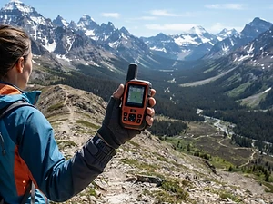
Satellite Messenger
Premium pickTwo-way messaging and SOS far from cell signal.
Garmin inReach Mini 2

Trekking Poles
Our pickSaves your knees on steep descents.
Cascade Mountain Tech Carbon Fiber Trekking Poles

Rain Jacket
Our pickBreathable storm shell with pit zips for climbs.
Outdoor Research Foray II
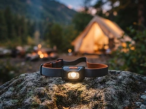
Headlamp
Our pickBright, weatherproof light with a red night mode.
Black Diamond Spot 450 Headlamp
As an Amazon Associate, Love Hiking Trails earns from qualifying purchases.
Photos

Ratings & Comments
—
No ratings yet
Sign in to rate this trail and leave a comment.
No comments yet. Share what the trail was like for you.
Nearby
Trails nearby
 StrenuousHike
Angels Landing
Zion National Park, Utah
A narrow sandstone spine with chain-assisted scrambling and thousand-foot drop-offs — Zion's most famous thrill hike.
Distance
5.4 mi
Difficulty
Strenuous
Type
Out and back
 ChallengingHike
The Narrows
Zion National Park, Utah
Wade up the Virgin River between towering slot-canyon walls that close to just 20 feet apart — one of the world's best hikes.
Distance
5 mi
Difficulty
Challenging
Type
Out and back (river hike)
 ChallengingHike
Observation Point (East Mesa)
Zion National Park, Utah
With the canyon route closed by rockfall, Observation Point is now reached by a nearly flat forest walk across the East Mesa. Reaching the trailhead means a high-clearance or 4WD dirt road.
Distance
6.8 mi
Difficulty
Challenging
Type
Out and back (East Mesa route)
More trails to explore
More trails in Nevada
Frequently asked questions
How long is the Wheeler Peak Summit Trail?
The park lists it at 8.6 miles round trip with about 3,100 feet of elevation gain, starting at 10,160 feet.
Is there an entrance fee?
No, Great Basin National Park has no entrance fee.
Are dogs allowed?
No, pets are not allowed on park trails.
When is the Scenic Drive open?
The upper road is usually open from June or July into fall, depending on snow.
How difficult is Wheeler Peak Summit Trail?
We rate it Expert (5 out of 5) for Great Basin National Park. That reflects its distance, 3,100 ft of climbing, and terrain.
When is the best time to hike Wheeler Peak Summit Trail?
The best window is July-September. Always check current conditions and weather before you go.
Do I need a permit or reservation for Wheeler Peak Summit Trail?
No special trail permit is required. Free.