

Nashville sits on the western edge of the Highland Rim: Radnor Lake is 20 minutes from downtown, and the rest of the best hiking is east and north of town — the waterfall country around Cookeville, the sandstone canyons of the Cumberland Plateau, and the big woods at Fall Creek Falls. Most of the hikes on this list are 75 to 135 miles from downtown, which is roughly 1½ to 2 hours by car once you're past traffic on I-40 or I-24.
Great Smoky Mountains National Park is a longer day: about 3½ hours to the nearest trailhead, so treat it as an overnight rather than a morning out. Everything here is in Tennessee state parks and state natural areas, and Tennessee state parks don't charge an entrance fee — you pay in driving time instead. The gorge route at Cummins Falls needs a permit in season, and the long plateau hikes need an early start.
Drive times below are approximate, from downtown Nashville by the fastest route, and they don't include weekend traffic or the gravel roads at some trailheads. Each card links to our full trail guide with distance, elevation, difficulty, fees, parking and tips. Check the park's page for closures before you go: the Cumberland Plateau waterfalls run best in spring and after rain.
The Best Hikes Near Nashville

Photo: Kaldari, CC0, via Wikimedia Commons. Radnor Lake State Park, Tennessee
Drive
About 20 min (9 mi)
Distance
3 mi of loops and connectors
Difficulty
Moderate; the lake trail is flat gravel, the ridge trails climb
Best for
Wildlife and a lake loop inside the city
Radnor Lake State Park is the closest real hike to downtown: a 1,200-acre wooded sanctuary around an 85-acre lake, ten minutes from Green Hills. The lake trail is flat and gravel and very good for birds, herons and winter waterfowl; the ridge trails above it add the climbing. It's a Class II Natural Area, so stay on the trail and leave the bike at home.

Photo: Brian Stansberry, CC BY 3.0, via Wikimedia Commons. Cummins Falls State Park, Tennessee
Drive
About 1 hr 20 min (85 mi)
Distance
2.5 mi round trip
Difficulty
Strenuous; the gorge route needs a permit
Best for
The closest big waterfall to Nashville
Cummins Falls is the state's largest waterfall by volume, and the full descent into the gorge is a rough, wet scramble over slick rock — the park requires a Gorge Access Permit for it. If you want the view without the scramble, stay on the overlook trail above the falls.

Photo: Ichabod, CC BY-SA 3.0, via Wikimedia Commons. Burgess Falls State Park, Tennessee
Drive
About 1 hr 30 min (90 mi)
Distance
1.5 mi round trip, with more via the upper trails
Difficulty
Easy to moderate
Best for
An easy family waterfall walk
A short, shaded walk on the Falling Water River leads to a series of cascades and the main drop at Burgess Falls. The overlook at the end is fenced, and there are stairs down toward the base. It's the gentlest of the Nashville-area waterfall hikes.

Photo: Earino, CC BY-SA 3.0, via Wikimedia Commons. Short Springs State Natural Area, Tennessee
Drive
About 1 hr 25 min (75 mi)
Distance
2 mi loop
Difficulty
Challenging; short but rocky, with creek crossings
Best for
Spring wildflowers and a short waterfall loop
Machine Falls sits in Short Springs State Natural Area near Tullahoma, a wooded slope of spring wildflowers, mossy rock and one very photogenic 60-foot waterfall. The loop down to the base is only 2 miles but it's rocky and rooty, with a creek crossing that runs high after rain. Go in April for the wildflowers and the strongest flow.
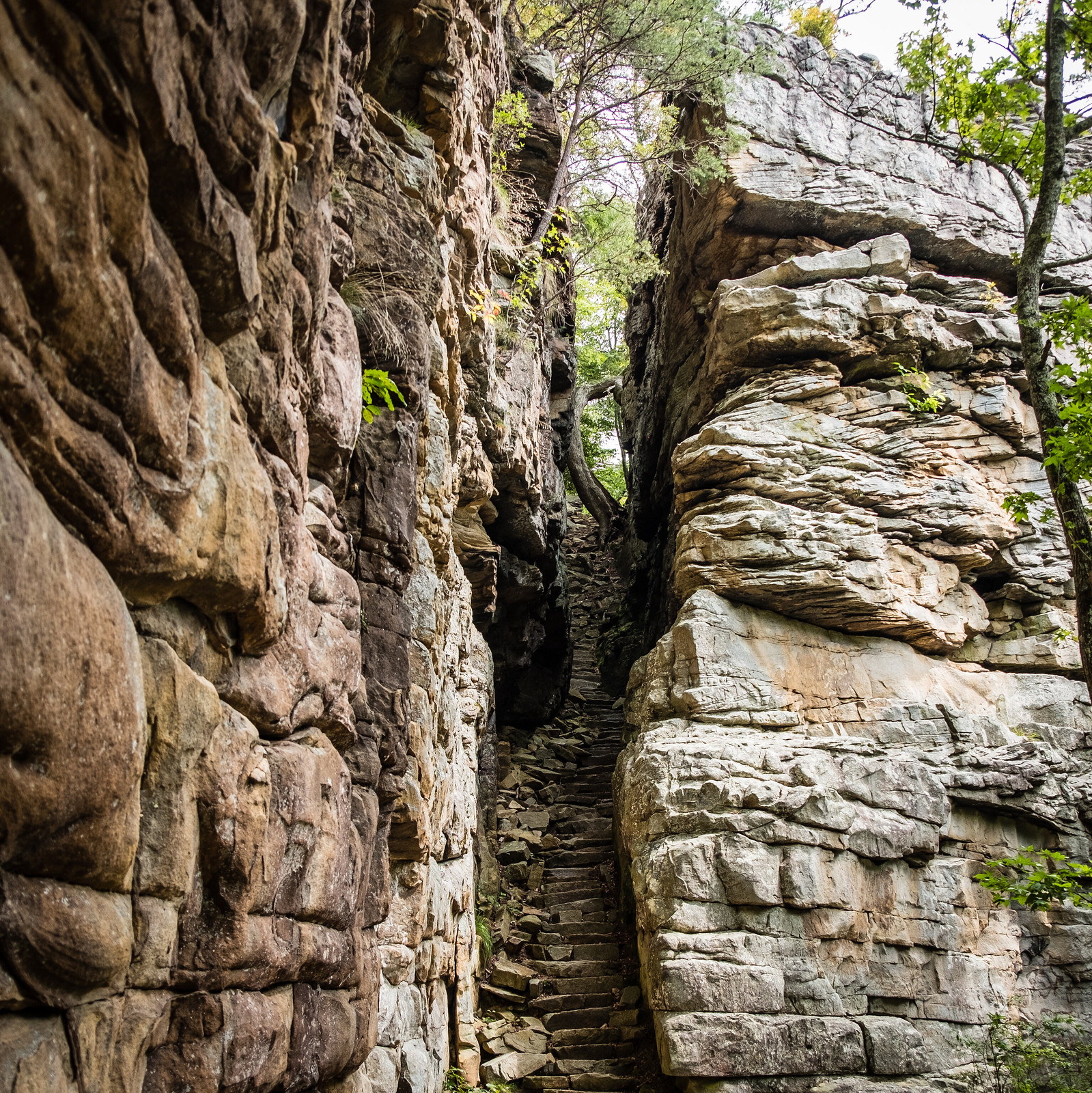
Photo: Sharon Mollerus, CC BY 2.0, via Flickr. Savage Gulf State Park, Tennessee
Drive
About 1 hr 50 min (105 mi)
Distance
0.9 mi round trip to the Door
Difficulty
Easy on the main path; hard down into the gulf
Best for
Big views for very little climbing
The Stone Door is a 100-foot crack in the plateau rim at Savage Gulf, with a stone staircase through it and a view over the gulf beyond. It's a short walk from the ranger station, and you can add the descent to Laurel Gulf or Big Creek if you want miles.

Photo: J. Michael Scarborough, CC BY-SA 3.0, via Wikimedia Commons. South Cumberland State Park, Tennessee
Drive
About 1 hr 45 min (105 mi)
Distance
12.8 mi one way end to end
Difficulty
Strenuous
Best for
A full-day plateau classic
The Fiery Gizzard climbs along rocky creekbeds and boulder fields below the plateau rim, past Fern Falls and the Blue Hole. It's the hardest full-day hike on this list and the least crowded, with a shuttle-friendly one-way layout if you can arrange two cars.

Photo: Silent melanie, Public domain, via Wikimedia Commons. Virgin Falls State Natural Area, Tennessee
Drive
About 2 hr (110 mi)
Distance
8.6 mi round trip
Difficulty
Strenuous
Best for
A waterfall that drops into a cave
Virgin Falls is a full-day out-and-back through the Scotts Gulf backcountry to a 110-foot falls that disappears underground. The creek crossings on the way are the crux; expect wet feet in spring and low water in late summer.

Photo: Michael W. Neu, Public domain, via Wikimedia Commons. Rock Island State Park, Tennessee
Drive
About 1 hr 45 min (105 mi)
Distance
1.6 mi round trip
Difficulty
Moderate; steep stairs and slick rock
Best for
A waterfall you can see from the trailhead
At Rock Island State Park the Collins River drops through a narrow chute beside the old cotton mill, and the Twin Falls overlook is a short walk from the parking area. The stairs down toward the river are steep and the rock stays wet.

Photo: Sharon Mollerus, CC BY 2.0, via Wikimedia Commons. Savage Gulf State Park, Tennessee
Drive
About 1 hr 40 min (95 mi)
Distance
0.8 mi loop
Difficulty
Moderate; short and steep
Best for
A quick swim-and-waterfall stop
The loop at Greeter Falls is short, steep and rewarding: a wide curtain of water into a plunge pool, with the Blue Hole just upstream. The stairs and boardwalk sections can be icy in winter.

Photo: Brian Stansberry, CC BY 3.0, via Wikimedia Commons. Ozone Falls State Natural Area, Tennessee
Drive
About 1 hr 50 min (105 mi)
Distance
4 mi loop
Difficulty
Challenging; the rim is easy, the scramble to the base is steep
Best for
A big waterfall five minutes off I-40
Ozone Falls drops about 110 feet over a sandstone lip just off I-40 at Crab Orchard, which makes it the easiest big waterfall on this list to reach. The overlook at the top is a two-minute walk; the descent to the plunge pool below is steep, loose and slippery, and the pool is not a swimming hole. Combine it with the Cumberland Mountain trails if you want more miles.

Photo: Ichabod, CC BY-SA 3.0, via Wikimedia Commons. Fall Creek Falls State Park, Tennessee
Drive
About 2 hr 10 min (135 mi)
Distance
2.6 mi round trip to the base
Difficulty
Strenuous on the descent
Best for
The biggest waterfall in the eastern U.S.
Fall Creek Falls drops 256 feet, and the trail down to the base is steep but short. The park has a full day's worth of other overlooks and trails, so it's the one hike here worth making an early start for.
Quick Tips for Hiking Near Nashville
- Tennessee state parks don't charge an entrance fee, but the Cummins Falls gorge route requires a Gorge Access Permit in season — check before you drive.
- Waterfalls on the Cumberland Plateau run best from March through May and after heavy rain. Late-summer flows can be a trickle.
- Start early on the long plateau hikes: Virgin Falls and the Fiery Gizzard take most of a day, and the trailheads fill on weekends.
- The Smokies are about 3½ hours east of Nashville. For those trails, use our separate Smokies guides instead of trying them as a day trip.