

At a glance
Elevation gain
Difficulty
Route type
Time
Permit required
Fees
Dogs
Best season
Official park info: National Forests in Alabama (Bankhead NF)
A trail along the Sipsey Fork through Alabama's largest wilderness of canyons and waterfalls.
The Sipsey River Trail follows the Sipsey Fork of the Black Warrior River, Alabama's only National Wild and Scenic River, into the heart of the Sipsey Wilderness in Bankhead National Forest. This is a landscape of sandstone bluffs, hemlock-shaded side canyons and waterfalls, and the Sipsey is often called the Land of a Thousand Waterfalls.
Overview
- Fall Creek Falls, one of the most visited waterfalls in the wilderness
- Towering sandstone bluffs and rock shelters above the river
- Old hemlocks and big hardwoods in the side hollows
- Swimming holes on hot days
Late winter and spring bring the strongest waterfalls and spring wildflowers. Fall is beautiful and comfortable. Summer is humid and buggy, and waterfalls shrink in dry spells.
Plan your visit
Trailhead map
Trailhead at 34.2856, -87.3987. Confirm current trail conditions before you go.
Where to stay near Sipsey River Trail
Find hotels and rentals near Sipsey River Trail
We may earn a commission if you book a stay through these links, at no extra cost to you. Prices and availability come from booking partners and can change. We never rank trails by commission.
Route, step by step
Most hikers start at the Sipsey River Picnic Area where Cranal Road (County Road 60) crosses the river. Trail 209 heads upstream along the riverbank beneath overhanging bluffs, passing small cascades where side streams tumble in. Within the first mile or so you reach Fall Creek Falls, which drops over a rock ledge into the river. Continue as far as you like before returning the same way; the trail links with other wilderness trails for longer trips, but junctions are not always well signed.
Tips
Show full route
- Pay the day-use fee at the trailhead.
- The river rises fast after storms; do not attempt crossings in high water.
- Carry a map or GPS track; wilderness trails are unblazed and can be confusing.
- Pack out everything, including food scraps.
Tips
- Pay the day-use fee at the trailhead.
What to bring & gear
- Sturdy hiking shoes or boots
- 2–3 liters of water per person
- Sun protection: hat, sunscreen, sunglasses
- Trail snacks or a packed lunch
- Rain shell
- Insect repellent
Picks sized to this trail's difficulty rating.
Our gear picks
Our picks for this hike. Compare current prices at Amazon.

Hiking Boots
Our pickSupport and grip for rocky, rooty miles.
Merrell Moab 3 Mid Waterproof

Daypack
Our pickCarries water, layers, and snacks comfortably.
Osprey Talon 22

Hydration Reservoir
Our pickWide-opening reservoir that's easy to fill and clean.
Platypus Big Zip EVO 3L Reservoir

Trekking Poles
Our pickSaves your knees on steep descents.
Cascade Mountain Tech Carbon Fiber Trekking Poles

Rain Jacket
Our pickBlocks sudden mountain storms and wind.
Columbia Watertight II Rain Jacket
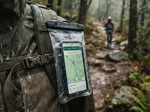
Phone Case
Budget pickKeeps your phone dry and usable in a wet pack or on the water.
Waterproof Phone Pouch
As an Amazon Associate, Love Hiking Trails earns from qualifying purchases.
Photos

Featured in: The Best Hikes Near Huntsville, Alabama
Ratings & Comments
—
No ratings yet
Sign in to rate this trail and leave a comment.
No comments yet. Share what the trail was like for you.
Nearby
More in Alabama
Trails nearby
 ModerateHike
Outcroppings Trail
Tishomingo State Park, Mississippi
A trail among sandstone outcrops and a swinging bridge in the Appalachian foothills of Mississippi.
Difficulty
Moderate
Type
Loop
 StrenuousHike
Walls of Jericho Trail
Walls of Jericho, Alabama
A descent into a limestone amphitheater on the Paint Rock River headwaters, called the Grand Canyon of the South.
Distance
6.6 mi
Difficulty
Strenuous
Type
Out & Back
 EasyHike
Little River Falls Trail
Little River Canyon National Preserve, Alabama
A short boardwalk to Little River Falls at the head of one of the deepest canyons in the Southeast.
Difficulty
Easy
Type
Out & Back
More trails to explore
More trails in Alabama
More hikes nearby
Frequently asked questions
How far is it to Fall Creek Falls?
It is roughly a mile upstream from the Sipsey River Picnic Area, so about 2 miles round trip.
Is there a fee?
Yes, a small day-use fee is charged at the Sipsey River Picnic Area trailhead.
Are dogs allowed?
Yes, dogs are allowed in the wilderness; keep them under control and on leash near others.
Can I camp along the trail?
Yes, dispersed camping is allowed in the Sipsey Wilderness; follow Leave No Trace practices.
How long is the Sipsey River Trail hike?
Most hikers complete Sipsey River Trail in Varies, though pace varies with conditions.
How difficult is Sipsey River Trail?
We rate it Challenging (3 out of 5) for Sipsey Wilderness (Bankhead National Forest). That reflects its distance and terrain.
When is the best time to hike Sipsey River Trail?
The best window is Spring and fall. Always check current conditions and weather before you go.
Do I need a permit or reservation for Sipsey River Trail?
No special trail permit is required. Day-use fee.