
At a glance
Distance
Elevation gain
Difficulty
Route type
Time
Permit required
Fees
Dogs
Best season
A trail to an overlook of a towering waterfall in the Jocassee Gorges.
Lower Whitewater Falls drops about 200 feet in the Jocassee Gorges of upstate South Carolina, one of the most impressive waterfalls in the Southeast. It's reached by a trail from the Bad Creek access area, operated by Duke Energy.
Overview
The Whitewater River makes a series of big drops as it plunges off the Blue Ridge Escarpment toward Lake Jocassee, first at Upper Whitewater Falls in North Carolina and then at Lower Whitewater Falls in South Carolina. The lower falls are best seen from the observation deck, which looks across the gorge to the white ribbon of water cascading down a granite face. The Jocassee Gorges are known for their high rainfall and rare plants, including the Oconee bell, which blooms in early spring.
- 200-foot Lower Whitewater Falls
- Jocassee Gorges
- Foothills Trail
The trail is good year-round. Spring has the best flow.
Plan your visit
Getting there
The Bad Creek access area is on SC Highway 130 north of Salem. Duke Energy operates the Bad Creek Hydroelectric Station, and the gate is open during daylight hours. Lower Whitewater Falls is on the Whitewater River, which flows into Lake Jocassee. Upper Whitewater Falls, across the line in North Carolina, is a separate hike.
Trailhead map
Trailhead at 35.0122, -82.9993. Confirm current trail conditions before you go.
Where to stay near Lower Whitewater Falls Trail
Find hotels and rentals near Lower Whitewater Falls Trail
We may earn a commission if you book a stay through these links, at no extra cost to you. Prices and availability come from booking partners and can change. We never rank trails by commission.
Route, step by step
From the Foothills Trail parking area at Bad Creek, follow the Foothills Trail, then the blue-blazed spur to the Lower Whitewater Falls overlook. The trail is moderately hilly. The round trip is about 3.8 miles. The trail follows the Foothills Trail through hardwood forest, crossing streams on bridges. The spur to the overlook descends to a viewing platform across the gorge from the falls. The trail is hilly, with some steep sections on the return.
Tips
Show full route
- The Bad Creek gate is open during daylight hours.
- Carry water.
- Stay at the overlook; the cliffs are dangerous.
- There is no fee.
Tips
- The Bad Creek gate is open during daylight hours.
What to bring & gear
- Sturdy hiking shoes or boots
- 2–3 liters of water per person
- Sun protection: hat, sunscreen, sunglasses
- Trail snacks or a packed lunch
- Rain shell
- Insect repellent
Picks sized to this trail's difficulty rating.
Our gear picks
Our picks for this hike. Compare current prices at Amazon.

Hiking Boots
Our pickSupport and grip for rocky, rooty miles.
Merrell Moab 3 Mid Waterproof

Daypack
Our pickCarries water, layers, and snacks comfortably.
Osprey Talon 22

Hydration Reservoir
Our pickWide-opening reservoir that's easy to fill and clean.
Platypus Big Zip EVO 3L Reservoir

Trekking Poles
Our pickSaves your knees on steep descents.
Cascade Mountain Tech Carbon Fiber Trekking Poles

Rain Jacket
Our pickBlocks sudden mountain storms and wind.
Columbia Watertight II Rain Jacket
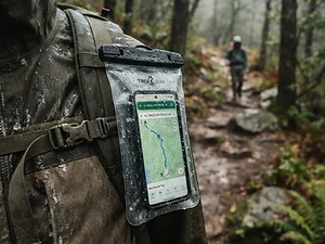
Phone Case
Budget pickKeeps your phone dry and usable in a wet pack or on the water.
Waterproof Phone Pouch
As an Amazon Associate, Love Hiking Trails earns from qualifying purchases.
Photos

Featured in: The Best Hikes Near Asheville, North Carolina, The Best Hikes Near Greenville, South Carolina, The Best Hikes in South Carolina
Ratings & Comments
—
No ratings yet
Sign in to rate this trail and leave a comment.
No comments yet. Share what the trail was like for you.
Nearby
More in South Carolina
Nearby bike trails
Nearby off-road
Trails nearby
 ModerateHike
Yellow Branch Falls
Sumter National Forest, South Carolina
A forest trail to a cascade over layered rock.
Distance
3.2 mi
Difficulty
Moderate
Type
Out & Back
 ExpertHike
Table Rock Trail
Table Rock State Park, South Carolina
A steep climb to the summit of Table Rock.
Distance
7.2 mi
Difficulty
Expert
Type
Out & Back
 ChallengingHike
Looking Glass Rock
Pisgah National Forest, North Carolina
Driving US-276 through Pisgah National Forest, it's hard to miss Looking Glass Rock: a massive granite dome whose wet rock faces shine like a mirror after rain. The trail to the top is a steady, switchbacking climb through changing forest to open rock with sweeping views north toward the Blue Ridge Parkway.
Distance
3.1 mi
Difficulty
Challenging
Type
Out-and-back
More trails to explore
More trails in South Carolina
More hikes nearby
Frequently asked questions
How long is the Lower Whitewater Falls trail?
It is about 3.8 miles round trip.
Is there a fee?
No, there is no fee.
Are dogs allowed?
Yes, leashed dogs are allowed.
When is the Bad Creek gate open?
Generally during daylight hours; you may exit any time.
How difficult is Lower Whitewater Falls Trail?
We rate it Challenging (3 out of 5) for Duke Energy Bad Creek. That reflects its distance, 200 ft of climbing, and terrain.
When is the best time to hike Lower Whitewater Falls Trail?
The best window is Year-round. Always check current conditions and weather before you go.
Do I need a permit or reservation for Lower Whitewater Falls Trail?
No special trail permit is required. Free.